Mantelau
Mantelau ist eine osttimoresische Siedlung im Suco Manutaci (Verwaltungsamt Ainaro, Gemeinde Ainaro).[1]
| Mantelau | |||
|---|---|---|---|
| |||
| Koordinaten | 8° 59′ S, 125° 31′ O | ||
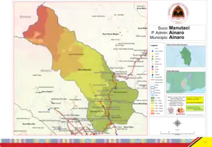 Karte des Sucos Manutaci Karte des Sucos Manutaci | |||
| Basisdaten | |||
| Staat | Osttimor | ||
| Ainaro | |||
| Verwaltungsamt | Ainaro | ||
| Suco | Manutaci | ||
| Aldeia | Bau-Hati-Lau | ||
| Höhe | 1011 m | ||
Geographie
Das Dorf Mantelau liegt im Osten der Aldeia Bau-Hati-Lau in einer Meereshöhe von 1011 m, an einer Abzweigung der Überlandstraße von Ainaro nach Maubisse. Im Südosten schließt sich das Dorf Poreme (Aldeia Canudo) an, der Abzweigung weiter nach Nordwesten folgend, erreicht man das Dorf Hato-Meta-Udo.[1] Westlich verläuft der Maumall, ein Nebenflusses des Belulik.[2]
Einzelnachweise
- Direcção-Geral de Estatística: Atlas der Gemeinde Ainaro, abgerufen am 28. Dezember 2021.
- Timor-Leste GIS-Portal (Memento vom 30. Juni 2007 im Internet Archive)
This article is issued from Wikipedia. The text is licensed under Creative Commons - Attribution - Sharealike. The authors of the article are listed here. Additional terms may apply for the media files, click on images to show image meta data.