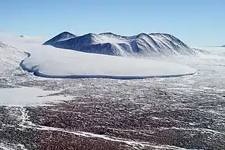
MacDonald Hills
Die MacDonald Hills sind eine kompakte Gruppe felsiger Hügel im ostantarktischen Viktorialand. Sie ragen östlich des Commonwealth-Gletschers auf der Nordseite des unteren Taylor Valley auf. Höchste Erhebung ist Mount Coleman mit 1110 m.
| MacDonald Hills | ||
|---|---|---|
 | ||
| Höchster Gipfel | Mount Coleman (1110 m) | |
| Lage | Viktorialand, Ostantarktika | |
| Teil der | Asgard Range im Transantarktischen Gebirge | |
| ||
| Koordinaten | 77° 33′ S, 163° 21′ O | |
Das Advisory Committee on Antarctic Names benannte das Gebirge 1997 nach William R. MacDonald (1925–1977), Leiter der Abteilung für internationale Aktivitäten des United States Geological Survey, Mitglied des Advisory Committee on Antarctic Names und von 1976 bis 1977 des United States Board on Geographic Names.
Weblinks
- MacDonald Hills im Geographic Names Information System des United States Geological Survey (englisch)
- MacDonald Hills auf geographic.org (englisch)
This article is issued from Wikipedia. The text is licensed under Creative Commons - Attribution - Sharealike. The authors of the article are listed here. Additional terms may apply for the media files, click on images to show image meta data.
