Maatsuyker-Inseln
Die Maatsuyker-Inseln sind eine zum australischen Bundesstaat Tasmania gehörende Inselgruppe im Südpazifik. Sie liegen nur wenige Kilometer vor der Südküste der Insel Tasmanien.
| Maatsuyker-Inseln | ||
|---|---|---|
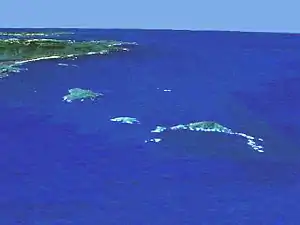 Lage der Maatsuyker-Inseln; oben links die tasmanische Südküste | ||
| Gewässer | Pazifischer Ozean | |
| Geographische Lage | 43° 38′ S, 146° 18′ O | |
| ||
| Anzahl der Inseln | 6 (+ 2 Felsgruppen) | |
| Hauptinsel | Maatsuyker Island | |
| Gesamte Landfläche | 8 km² | |
| Einwohner | unbewohnt | |
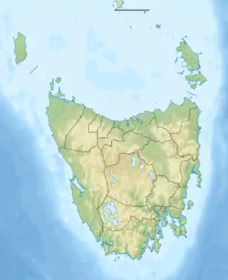
 Karte der Maatsuyker-Inseln | ||
Geographie
![]() Karte mit allen Koordinaten: OSM | WikiMap
Karte mit allen Koordinaten: OSM | WikiMap
Zur Gruppe, die sich von Nordost nach Südwest über etwa 13 Kilometer Luftlinie erstreckt, gehören sechs kleine Inseln und zwei Felsinselgruppen:
| Inselname | Aliasname | Koordinaten | Fläche | Einwohner | Anmerkung |
|---|---|---|---|---|---|
| De Witt Island | 43° 36′ S, 146° 21′ O | 5,17 | - | ||
| Flat Witch Island | 43° 37′ S, 146° 17′ O | 0,64 | - | ||
| Walker Island | 43° 38′ S, 146° 16′ O | 0,15 | - | ||
| Western Rocks | 43° 38′ S, 146° 19′ O | 0,01 | - | Inselgruppe | |
| Flat Top Island | 43° 38′ S, 146° 23′ O | 0,01 | - | ||
| Round Top Island | 43° 39′ S, 146° 22′ O | 0,01 | - | ||
| Maatsuyker Island | 43° 39′ S, 146° 17′ O | 1,86 | - | ||
| Needle Rocks | 43° 40′ S, 146° 15′ O | 0,15 | - | Inselgruppe |
Mitunter werden, obwohl weit ablegen, hinzugezählt: die Breaksea Islands, Eddystone Rock, Kathleen Islands, Mewstone, Pedra Branca, Shanks Islands sowie die Trumpeter-Inseln.
Nutzung
Lediglich auf der Hauptinsel Maatsuyker Island befinden sich Bauten, ein heute automatisch betriebener Leuchtturm und eine unbemannte Wetterstation sowie ein kleiner Hubschrauberlandeplatz.
Die Inseln sind Teil des Southwest-Nationalparks von Tasmanien.
Weblinks
- Leuchtturm und Wetterstation auf Maatsuyker Island (bebildert, engl.)