Liste der Einträge im National Register of Historic Places im Sumter County (Alabama)
Die Liste der Registered Historic Places im Sumter County führt alle Bauwerke und historischen Stätten im Sumter County in Alabama auf, die in das National Register of Historic Places aufgenommen wurden.
Aktuelle Einträge
| [1] | Name | Bild | Eintragsdatum | Lage | Ort | Beschreibung |
|---|---|---|---|---|---|---|
| 1 | Dr. James Alvis Beavers House |  Dr. James Alvis Beavers House |
31. Aug. 2000 ID-Nr. 00001025 |
Old Livingston Rd. 32° 26′ 20″ N, 88° 21′ 43,3″ W |
Cuba | |
| 2 | Coffin Shop | 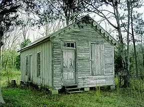 Coffin Shop |
29. Okt. 1985 ID-Nr. 85002930 |
McKee and Monroe Sts. 32° 49′ 17,6″ N, 88° 9′ 29,7″ W |
Gainesville | |
| 3 | Colgin Hill | 3. Okt. 1985 ID-Nr. 85002924 |
Off State Route 39 32° 48′ 40,3″ N, 88° 9′ 20,1″ W |
Gainesville | ||
| 4 | Fort Tombecbee |  Fort Tombecbee |
2. Okt. 1973 ID-Nr. 73000373 |
32° 41′ 53″ N, 88° 7′ 4″ W |
Epes | |
| 5 | Gainesville Historic District | 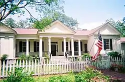 Gainesville Historic District |
3. Okt. 1985 ID-Nr. 85002925 |
Roughly bounded by North Carolina, Church, School, and Lafayette Sts., end of the town grid, and Webster St. 32° 49′ 0,5″ N, 88° 9′ 26,1″ W |
Gainesville | |
| 6 | Gibbs House |  Gibbs House |
3. Okt. 1985 ID-Nr. 85002926 |
Southwest of Spruce and Webster Sts. 32° 48′ 47,5″ N, 88° 9′ 52,6″ W |
Gainesville | |
| 7 | Main–Yankee Street Historic District |  Main–Yankee Street Historic District weitere Bilder |
3. Okt. 1985 ID-Nr. 85002927 |
Roughly bounded by Main, Washington, and School Sts. 32° 49′ 21,5″ N, 88° 9′ 21,1″ W |
Gainesville | |
| 8 | Col. Green G. Mobley House |  Col. Green G. Mobley House |
18. Jan. 1982 ID-Nr. 82002070 |
Webster and Pearl Sts. 32° 49′ 5,6″ N, 88° 9′ 37,8″ W |
Gainesville | |
| 9 | Oakhurst |  Oakhurst weitere Bilder |
6. Jan. 1987 ID-Nr. 86003563 |
Gainesville-Lacy's Ford Rd., etwa 4,8 km südwestlich von State Route 116 32° 46′ 47,6″ N, 88° 16′ 8,8″ W |
Emelle | |
| 10 | Park and Bandstand | 29. Okt. 1985 ID-Nr. 85002929 |
State and McKee Sts. 32° 49′ 22,4″ N, 88° 9′ 30,1″ W |
Gainesville | ||
| 11 | Sumter County Courthouse |  Sumter County Courthouse |
24. März 1972 ID-Nr. 72000180 |
U.S. Route 11 32° 34′ 57,9″ N, 88° 11′ 18″ W |
Livingston | |
| 12 | Dr. H. B. Ward House | 14. Aug. 1998 ID-Nr. 98001020 |
202 4th Ave. 32° 25′ 42″ N, 88° 22′ 32,8″ W |
Cuba | ||
| 13 | Laura Watson House | 3. Okt. 1985 ID-Nr. 85002928 |
Epes Rd. 32° 48′ 52,2″ N, 88° 9′ 11,4″ W |
Gainesville | abgegangenes Bauwerk |
Siehe auch
Weblinks
- Suchmaske Datenbank im National Register Information System, National Park Service
Einzelnachweise
- Die Nummerierung in dieser Listenspalte ist an der vom National Park Service vorgelegten Reihenfolge der Einträge orientiert; die Farben unterscheiden verschiedene Schutzgebietstypen des National Park Systems mit landesweiter Bedeutung (z. B. National Historic Landmarks) von den sonstigen Einträgen im National Register of Historic Places.
National Register of Historic Places in Alabama
Autauga | Baldwin | Barbour | Bibb | Blount | Bullock | Butler | Calhoun | Chambers | Cherokee | Chilton | Choctaw | Clarke | Clay | Cleburne | Coffee | Colbert | Conecuh | Coosa | Covington | Crenshaw | Cullman | Dale | Dallas | DeKalb | Elmore | Escambia | Etowah | Fayette | Franklin | Geneva | Greene | Hale | Henry | Houston | Jackson | Jefferson | Lamar | Lauderdale | Lawrence | Lee | Limestone | Lowndes | Macon | Madison | Marengo | Marion | Marshall | Mobile | Monroe | Montgomery | Morgan | Perry | Pickens | Pike | Randolph | Russell | Shelby | St. Clair | Sumter | Talladega | Tallapoosa | Tuscaloosa | Walker | Washington | Wilcox | Winston