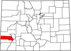
Liste der Einträge im National Register of Historic Places im San Miguel County (Colorado)
Die Liste der Einträge im National Register of Historic Places im San Miguel County in Colorado führt die Bauwerke und historischen Stätten im San Miguel County auf, die in das National Register of Historic Places aufgenommen wurden.[1]
- Legende
| NRHP | Historic Place |
|---|---|
| HD | Historic District |
| NHL | National Historic Landmark |
| [2] | Name | Bild | Eintragsdatum | Lage | Ort | Beschreibung |
|---|---|---|---|---|---|---|
| 1 | Fort Peabody | 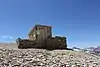 Fort Peabody |
30. März 2005 ID-Nr. 05000214 |
Uncompahgre National Forest 37° 55′ 49″ N, 107° 43′ 57″ W |
Telluride | |
| 2 | Lewis Mill | 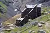 Lewis Mill |
6. Mai 2009 ID-Nr. 09000267 |
3,5 Meilen südöstlich von Telluride 37° 52′ 44,4″ N, 107° 46′ 30″ W |
Telluride | |
| 3 | Rio Grande Southern Railroad Trout Lake Water Tank | 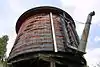 Rio Grande Southern Railroad Trout Lake Water Tank |
21. Aug. 2003 ID-Nr. 03000777 |
Along North Trout Lake Rd. 37° 49′ 23″ N, 107° 52′ 45″ W |
Ophir | |
| 4 | Smuggler-Union Hydroelectric Power Plant | 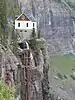 Smuggler-Union Hydroelectric Power Plant |
27. Dez. 1979 ID-Nr. 79000621 |
Südöstlich von Telluride 37° 55′ 9″ N, 107° 46′ 8″ W |
Telluride | |
| 5 | Telluride Historic District | 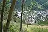 Telluride Historic District |
15. Okt. 1966 ID-Nr. 66000256 |
State Highway 145 37° 56′ 14″ N, 107° 48′ 29″ W |
Telluride | |
| 6 | Valley View Leasing and Mining Company Mill | 24. Feb. 2010 ID-Nr. 10000035 |
State Highway 145, 2,8 Meilen südlich von Ophir 37° 50′ 49,2″ N, 107° 53′ 2,4″ W |
Ophir |
Siehe auch
Weblinks
Einzelnachweise
- Auszug aus dem National Register of Historic Places - San Miguel County, abgerufen am 30. November 2017
- Die Nummerierung in dieser Listenspalte ist an der vom National Park Service vorgelegten Reihenfolge der Einträge orientiert; die Farben unterscheiden verschiedene Schutzgebietstypen des National Park Systems mit landesweiter Bedeutung (z. B. National Historic Landmarks) von den sonstigen Einträgen im National Register of Historic Places.
National Register of Historic Places in Colorado
Adams | Alamosa | Arapahoe | Archuleta | Baca | Bent | Boulder | Broomfield | Chaffee | Cheyenne | Clear Creek | Conejos | Costilla | Crowley | Custer | Delta | Denver | Dolores | Douglas | Eagle | El Paso | Elbert | Fremont | Garfield | Gilpin | Grand | Gunnison | Hinsdale | Huerfano | Jackson | Jefferson | Kiowa | Kit Carson | La Plata | Lake | Larimer | Las Animas | Lincoln | Logan | Mesa | Mineral | Moffat | Montezuma | Montrose | Morgan | Otero | Ouray | Park | Phillips | Pitkin | Prowers | Pueblo | Rio Blanco | Rio Grande | Routt | Saguache | San Juan | San Miguel | Sedgwick | Summit | Teller | Washington | Weld | Yuma