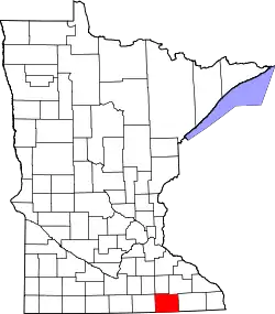
Liste der Einträge im National Register of Historic Places im Mower County
Die Liste der Einträge im National Register of Historic Places im Mower County in Minnesota führt alle Bauwerke und historischen Stätten im Mower County auf, die in das National Register of Historic Places aufgenommen wurden.[1]
Legende
| NRHP | Historic Place |
|---|---|
| HD | Historic District |
Aktuelle Einträge
| [2] | Name[3] | Bild | Eintragsdatum | Lage | Ort | Beschreibung |
|---|---|---|---|---|---|---|
| 1 | Booth Post No. 130-Grand Army of the Republic Hall | 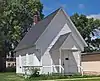 Booth Post No. 130-Grand Army of the Republic Hall |
1986 ID-Nr. 86001278 |
South Main Street zwischen 1st Street und 2nd Street 43° 42′ 15″ N, 92° 34′ 22″ W |
Grand Meadow | |
| 2 | Cook-Hormel House |  Cook-Hormel House |
1982 ID-Nr. 82002989 |
208 4th Avenue, Northwest 43° 40′ 16″ N, 92° 59′ 38″ W |
Austin | 1871 im Italianate-Stil errichtetes Haus des Politikers John Cook; Der spätere Eigentümer, der Unternehmer George A. Hormel (Gründer der Hormel Foods Corporation), ließ die Fassade im klassizistischen Stil umbauen |
| 3 | Exchange State Bank | 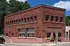 Exchange State Bank |
1975 ID-Nr. 75000997 |
Main Street Ecke 1st Street 43° 42′ 22″ N, 92° 34′ 16″ W |
Grand Meadow | |
| 4 | First National Bank of Adams | 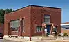 First National Bank of Adams |
1986 ID-Nr. 86000442 |
322 Main Street 43° 34′ 3″ N, 92° 43′ 7″ W |
Adams | |
| 5 | First State Bank of Le Roy | 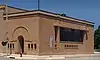 First State Bank of Le Roy |
1986 ID-Nr. 86000445 |
Main Street Ecke Broadway 43° 30′ 36″ N, 92° 30′ 13″ W |
Le Roy | |
| 6 | Freund Store |  Freund Store |
1986 ID-Nr. 86000867 |
County Highway 7 43° 30′ 19″ N, 92° 46′ 10″ W |
Adams | |
| 7 | Grand Meadow Quarry Archeological District | 1994 ID-Nr. 94000345 |
Adresse nicht veröffentlicht |
Grand Meadow | ||
| 8 | LeRoy Public Library |  LeRoy Public Library |
1986 ID-Nr. 86000447 |
Luella Street Ecke Broadway 43° 30′ 41″ N, 92° 30′ 13″ W |
Le Roy | |
| 9 | Paramount Theater | 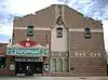 Paramount Theater |
1986 ID-Nr. 86002906 |
125 4th Avenue, Northeast 43° 40′ 12″ N, 92° 58′ 24″ W |
Austin | |
| 10 | Arthur W. Wright House |  Arthur W. Wright House |
1986 ID-Nr. 86000441 |
300 4th Avenue, Northwest 43° 40′ 12″ N, 92° 58′ 38″ W |
Austin |
Siehe auch
Einzelnachweise
- Auszug aus dem National Register of Historic Places - Mower County Abgerufen am 25. Januar 2013
- Die Nummerierung in dieser Listenspalte ist an der vom National Park Service vorgelegten Reihenfolge der Einträge orientiert; die Farben unterscheiden verschiedene Schutzgebietstypen des National Park Systems mit landesweiter Bedeutung (z. B. National Historic Landmarks) von den sonstigen Einträgen im National Register of Historic Places.
- National Register Information System. In: National Register of Historic Places. National Park Service. Abgerufen am 9. Juli 2010.
National Register of Historic Places in Minnesota
Aitkin | Anoka | Becker | Beltrami | Benton | Big Stone | Blue Earth | Brown | Carlton | Carver | Cass | Chippewa | Chisago | Clay | Clearwater | Cook | Cottonwood | Crow Wing | Dakota | Dodge | Douglas | Faribault | Fillmore | Freeborn | Goodhue | Grant | Hennepin | Houston | Hubbard | Isanti | Itasca | Jackson | Kanabec | Kandiyohi | Kittson | Koochiching | Lac qui Parle | Lake | Lake of the Woods | Le Sueur | Lincoln | Lyon | Mahnomen | Marshall | Martin | McLeod | Meeker | Mille Lacs | Morrison | Mower | Murray | Nicollet | Nobles | Norman | Olmsted | Otter Tail | Pennington | Pine | Pipestone | Polk | Pope | Ramsey | Red Lake | Redwood | Renville | Rice | Rock | Roseau | Scott | Sherburne | Sibley | St. Louis | Stearns | Steele | Stevens | Swift | Todd | Traverse | Wabasha | Wadena | Waseca | Washington | Watonwan | Wilkin | Winona | Wright | Yellow Medicine