Liste der Baudenkmale in Ongaonga
Die Liste der Baudenkmale in Ongaonga umfasst alle vom New Zealand Historic Places Trust (NZHPT) als „Historic Place“ oder „Historic Area“ eingestuften Baudenkmale und Flächendenkmale der neuseeländischen Ortschaft Ongaonga. Die Angaben stammen aus dem Register des NZHPT. Die Bezeichnungen der Baudenkmale orientieren sich an diesem Register. In die Liste werden auch bekannte Wahi Tapu (Area), kulturell und religiös bedeutsame Stätten und Gebiete der Māori, aufgenommen. Sie werden jedoch meist nicht publiziert.
| Bild | Bezeichnung | Ort | Anschrift | Beschreibung | Bauzeit | Eintrag | Nummer | Kat. |
|---|---|---|---|---|---|---|---|---|
 weitere Bilder |
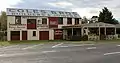
Coles Joinery Factory | Ongaonga | 54 Bridge Street Karte |
ehem. Bauunternehmen /Schreinerei | n.a. | 1. September 1993 | 172 | 1 |
| Forest Gate Station Homestead | Ongaonga | State Highway 50 1730 Karte |
Wohnhaus | n.a. | 7. April 1983 | 1037 | 2 | |
| Forest Gate Dairy Safe Shed | Ongaonga | State Highway 50 1730 Karte |
als Safe genutzter Schuppen | n.a. | 7. April 1983 | 1038 | 2 | |
.JPG.webp) weitere Bilder |
Butchers Shop (Former) | Ongaonga | Bridge Street Karte |
Metzgerei, ehemalige | n.a. | 7. April 1983 | 1039 | 2 |
| Coles Joinery Factory Outbuildings (Former) | Ongaonga | 54 Bridge Street Karte |
Nebengebäude der Schreinerei Coles | n.a. | 7. April 1983 | 1040 | 2 | |
.JPG.webp) weitere Bilder |
School House (Former) | Ongaonga | Bridge Street Karte |
Schule, ehemalige | n.a. | 7. April 1983 | 1042 | 2 |
.JPG.webp) weitere Bilder |
Town Hall (Former) | Ongaonga | Bridge Street Karte |
Rathaus, ehemaliges | n.a. | 7. April 1983 | 1043 | 2 |
| House (Laughlin McKay) | Ongaonga | Bridge Street Karte |
Wohnhaus | n.a. | 7. April 1983 | 1045 | 2 | |
| House (William Ross) | Ongaonga | Bridge Street Karte |
Wohnhaus | n.a. | 7. April 1983 | 1046 | 2 | |
| House (Ross Sutton) | Ongaonga | Bridge Street Karte |
Wohnhaus | n.a. | 7. April 1983 | 1047 | 2 | |
.JPG.webp) weitere Bilder |
Poodles Bazaar (Formerly Ongaonga General Store) | Ongaonga | Bridge Street Karte |
Gemischtwarenladen, ehemaliger | 1911 (an Gebäudefassade) | 7. April 1983 | 1051 | 2 |
.JPG.webp) weitere Bilder |
Post Office (Former) | Ongaonga | Bridge Street Karte |
Postamt, ehemaliges | n.a. | 7. April 1983 | 1052 | 2 |
.JPG.webp) weitere Bilder |
St Oran's Church (Presbyterian-Methodist Co-operating Parish) | Ongaonga | Bridge Street Karte |
Kirche, presbyterianisch und methodistisch | n.a. | 7. April 1983 | 1054 | 2 |
| War Memorial | Ongaonga | Bridge Street Karte |
Denkmal für den Ersten Weltkrieg | n.a. | 7. April 1983 | 1058 | 2 | |
| Church of the Good Shepherd (Anglican) | Ongaonga | Bridge Street Karte |
Kirche, anglikanische | n.a. | 7. April 1983 | 2751 | 2 | |
| Forest Gate Station Woolshed | Ongaonga | State Highway 50 1730 Karte |
Schafschurschuppen | n.a. | 7. April 1983 | 2752 | 2 | |
| Forest Gate Station Stables and Coach House | Ongaonga | State Highway 50 1730 Karte |
Stall und Garage | n.a. | 7. April 1983 | 2753 | 2 | |
| House (Mr Doug Simpson) | Ongaonga | Mill Street Karte |
Wohnhaus | n.a. | 7. April 1983 | 2755 | 2 |
This article is issued from Wikipedia. The text is licensed under Creative Commons - Attribution - Sharealike. The authors of the article are listed here. Additional terms may apply for the media files, click on images to show image meta data.