Liste der Baudenkmale in Masterton
Die Liste der Baudenkmale in Masterton umfasst alle vom New Zealand Historic Places Trust (NZHPT) als „Historic Place“ oder „Historic Area“ eingestuften Baudenkmale und Flächendenkmale der neuseeländischen Ortschaft Masterton. Die Angaben stammen aus dem Register des NZHPT. Die Bezeichnungen der Baudenkmale orientieren sich an diesem Register. In die Liste werden auch bekannte Wahi Tapu (Area), kulturell und religiös bedeutsame Stätten und Gebiete der Māori, aufgenommen. Sie werden jedoch meist nicht publiziert.
| Bild | Bezeichnung | Ort | Anschrift | Beschreibung | Bauzeit | Eintrag | Nummer | Kat. |
|---|---|---|---|---|---|---|---|---|
| Rabbit Fence - Omahu Farm | Masterton | Stronvar Road Karte |
Kaninchenzaun | 1881–1882 | 21. September 1989 | 3960 | 1 | |
| Fairburn Station Stables | Masterton | East Taratahi Road Karte |
Stall | n.a. | 23. Juni 1983 | 1289 | 2 | |
| Mayfield Station Woolshed | Masterton | Bristol Road, R.D. 7 Karte |
Schafschurschuppen | n.a. | 23. Juni 1983 | 1291 | 2 | |
.jpg.webp) weitere Bilder |
Brentwood | Masterton | 127 Upper Plain Road Karte |
Wohnhaus | n.a. | 23. Juni 1983 | 1316 | 2 |
 weitere Bilder |
House | Masterton | 20 McKenna Street Karte |
Wohnhaus | 1904 (ca.) | 23. Juni 1983 | 1317 | 2 |
 weitere Bilder |
Natusch House | Masterton | 55 Lincoln Road Karte |
Wohnhaus | n.a. | 23. Juni 1983 | 1318 | 2 |
 weitere Bilder |
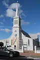
St Patrick's Church (Catholic), including Cast-Iron Railing Fence and Gate | Masterton | 375 Queen Street und Russell Street Karte |
Kirche, katholische einschließlich Zaun und Tor | n.a. | 23. Juni 1983 | 1319 | 2 |
| ICA Building | Masterton | Langdale Road Karte |
Gebäude einer Farm | n.a. | 23. Juni 1983 | 2859 | 2 | |
| Otahuao | Masterton | 491 Masterton-Castlepoint Road Karte |
Wohnhaus | n.a. | 23. Juni 1983 | 2860 | 2 | |
| Jeans-Hacker House | Masterton | 60 Church Street Karte |
Wohnhaus | 1860er, frühe | 23. Juni 1983 | 2880 | 2 | |
| Mayfield Station Stables | Masterton | Bristol Road, R D 7 Karte |
Stall | n.a. | 23. Juni 1083 | 7163 | 2 | |
| Mayfield Station Shed | Masterton | Bristol Road, R D 7 Karte |
Schuppen | n.a. | 23. Juni 1083 | 7164 | 2 | |
 weitere Bilder |
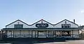
Sample Rooms | Masterton | 64 Dixon Street Karte |
ehemals Musterausstellung reisender Vertreter | n.a. | 23. Juni 1994 | 7204 | 2 |
 weitere Bilder |
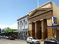
National Bank Building | Masterton | 189-191 Queen Street Karte |
Bankfiliale | 1871 | 13. Februar 1997 | 7374 | 2 |
 weitere Bilder |
Wairarapa Times-Age Building | Masterton | 70 Chapel Street und Cole Street Karte |
Zeitungsverlag | 1837 | 30. Juni 2006 | 7666 | 2 |
 weitere Bilder |
Homebush | Masterton | 10 Homebush Road Karte (ungenau) |
Wohnhaus | n.a. | 15. Dezember 2006 | 7685 | 2 |
| Solway A & P Showgrounds Historic Area | Masterton | 80 York Street Karte |
Gelände einer Landwirtschaftsschau | 1911 | 6. April 2001 | 7488 | HA | |
| Te Maipi | Masterton | Te Maipi Road and Motukai Road, Ngaumu Karte |
n.a. | n.a. | 29. August 2002 | 7523 | WTA |
This article is issued from Wikipedia. The text is licensed under Creative Commons - Attribution - Sharealike. The authors of the article are listed here. Additional terms may apply for the media files, click on images to show image meta data.