Lapuente (Uruguay)
Lapuente, auch als La Puente geführt, ist eine Ortschaft in Uruguay.
| Lapuente | ||
|---|---|---|
|
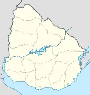
Lapuente auf der Karte von Uruguay | ||
| Basisdaten | ||
| Staat | Uruguay | |
| Departamento | Rivera | |
| Einwohner | 321 (2011) | |
| Detaildaten | ||
| Postleitzahl | 40004[1] | |
Geographie
Sie befindet sich im Sektor 7 des Departamento Rivera. Dort liegt sie nordöstlich von Amarillo, nördlich von Moirones und östlich des Ortes Cerro Pelado. In östlicher Richtung liegt an der Grenze zum Nachbarland Brasilien die Ortschaft Cerrillada.
Einwohner
Bei der Volkszählung im Jahr 2011 hatte Lapuente 321 Einwohner, davon 178 männliche und 143 weibliche.[2]
| Jahr | Einwohner |
|---|---|
| 1963 | 412 |
| 1975 | 292 |
| 1985 | 268 |
| 1996 | 284 |
| 2004 | 315 |
| 2011 | 321 |
Weblinks
- Stadtplan von Lapuente (PDF; 84 kB)
Einzelnachweise
- Postleitzahlenverzeichnis der uruguayischen Post
- Statistische Daten des Instituto Nacional de Estadística de Uruguay, abgerufen am 21. September 2012
- Statistische Daten des Instituto Nacional de Estadística de Uruguay 1963–1996 (DOC; 123 kB)
- Statistische Daten des Instituto Nacional de Estadística de Uruguay 2004 als xls-Datei
This article is issued from Wikipedia. The text is licensed under Creative Commons - Attribution - Sharealike. The authors of the article are listed here. Additional terms may apply for the media files, click on images to show image meta data.
