Kap Lindsey
Kap Lindsey ist ein Kap am westlichen Ende von Elephant Island im Archipel der Südlichen Shetlandinseln. Es markiert die nördliche Begrenzung der Rodman Cove.
| Kap Lindsey | ||
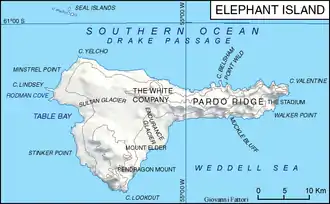 Karte von Elephant Island mit Kap Lindsey (links) | ||
| Geographische Lage | ||
| ||
| Koordinaten | 61° 6′ S, 55° 29′ W | |
| Lage | Elephant Island (Südliche Shetlandinseln) | |
| Gewässer | Drakepassage | |
| Gewässer 2 | Rodman Cove | |

Der Name des Kaps erscheint erstmals auf einer Landkarte aus dem Jahr 1822, die auf den Kartierungen des britischen Robbenfängerkapitäns George Powell basiert. Der weitere Benennungshintergrund ist nicht überliefert.
Weblinks
- Cape Lindsey im Geographic Names Information System des United States Geological Survey (englisch)
- Cape Lindsey auf geographic.org (englisch)
This article is issued from Wikipedia. The text is licensed under Creative Commons - Attribution - Sharealike. The authors of the article are listed here. Additional terms may apply for the media files, click on images to show image meta data.