Johnson’s Harbour
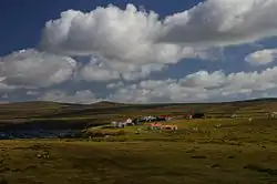
Die Siedlung Johnson’s Harbour (spanisch Puerto Johnson)[1] liegt an der nordöstlichen Küste von Ostfalkland am Ufer des Berkeley Sound. An der Mündung des Chabot Creeks gelegen, ist sie von Bergen wie dem Diamond Mountain, North Lookout und Hawk Hill umgeben. Im Ort gibt es einen kleinen Laden und einen Rollstreifen für Notflüge des Falkland Islands Government Air Service (FIGAS).
| Johnson’s Harbour | |||
|---|---|---|---|
| |||
| Koordinaten | 51° 30′ S, 58° 2′ W | ||
| Basisdaten | |||
| Staat | Falklandinseln | ||
 Johnson’s Harbour Johnson’s Harbour | |||
Literatur
- Falkland Islands Shores, Ewen Southby-Tailyour, 1985, Nautical, ISBN 9997354842, ISBN 978-9997354846
This article is issued from Wikipedia. The text is licensed under Creative Commons - Attribution - Sharealike. The authors of the article are listed here. Additional terms may apply for the media files, click on images to show image meta data.