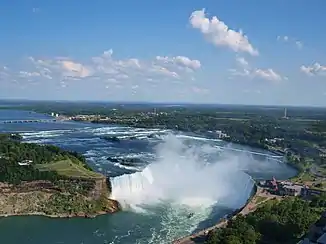
Horseshoe Falls
Die Horseshoe Falls (deutsch „Hufeisenfälle“), auch Canadian Falls genannt, bilden einen Teil der Niagarafälle. Etwa 90 Prozent des Wassers des Niagara fließen, nach Umleitungen zur Energieerzeugung durch Wasserkraft, über die Horseshoe Falls, die sich zwischen Terrapin Point auf Goat Island im US-Bundesstaat New York und Table Rock in der kanadischen Provinz Ontario befinden.[1][2]
| Horseshoe Falls | ||
|---|---|---|
 Horseshoe Falls Horseshoe Falls | ||
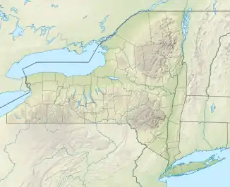
| Koordinaten | 43° 5′ 0″ N, 79° 4′ 15″ W | |
| ||
| Ort | Niagara Falls (New York) | |
| Höhe | Fallkante: 51 m | |
| Breite | 820 m | |
| Fluss | Niagara River | |
Internationale Grenze
Als 1819 der Grenzverlauf zwischen den USA und Kanada im Frieden von Gent bestimmt wurde, lag das nordöstliche Ende der Horseshoe Falls im Bundesstaat New York bei den Terrapin Rocks, die früher über verschiedene Brücken mit Goat Island verbunden waren. 1955 wurde der Bereich zwischen den Felsen und Goat Island aufgefüllt; Terrapin Point entstand.[3] In den frühen 1980er Jahren erweiterte das United States Army Corps of Engineers die Landauffüllung und errichtete Dämme, um das Wasser von Terrapin Point fortzuleiten. Dadurch verschwanden über 100 Meter der Horseshoe Falls.
Gemäß den offiziellen Karten der USA und Kanadas befindet sich ein kleiner Teil der Horseshoe Falls in den Vereinigten Staaten.[4][5]
Galerie
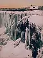 Die gefrorenen Horseshoe Falls, um 1900
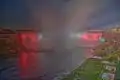 Horseshoe Falls bei Nacht mit Beleuchtung zu touristischen Zwecken
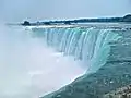 Horseshoe Falls, gesehen vom Table Rock Centre in Niagara Falls, Ontario
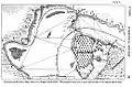 Karte der internationalen Grenze durch die Horseshoe Falls der Boundary Commission von 1819
Weblinks
Einzelnachweise
- Matthew Lee (29. Oktober 2007). Video claims Horseshoe Falls for U.S. Toronto Star
- "The international boundary line may pass through the Horseshoe Falls just beyond Terrapin Tower Point, so that the United States are not entitled to as large a portion as Canada of the Horseshoe Falls, which is admittedly not all Canadian." Statement of Mr. J Boardman Scovell. Preservation of Niagara Falls: hearings on the subject of H.R. 26688, Sixty-first Congress, second session, relating to the control and regulation of the waters of Niagara River and the preservation of Niagara Falls, held before the Committee on Rivers and Harbors of the House of Representatives. U.S. G.P.O., 1911
- Pierre Berton: Niagara: A History of the Falls. SUNY Press, 2009, ISBN 978-1-4384-2928-1, S. 20–21 (Abgerufen am 1. Dezember 2010).
- The Atlas of Canada. Government of Canada. Abgerufen am 19. Februar 2017.
- National Map of the United States. United States Geological Survey. Abgerufen am 19. Februar 2017.