Hoholete (Ort)
Hoholete ist ein osttimoresischer Ort im Suco Fatubossa (Verwaltungsamt Aileu, Gemeinde Aileu).[1]
| Hoholete | |||
|---|---|---|---|
| |||
| Koordinaten | 8° 50′ S, 125° 33′ O | ||
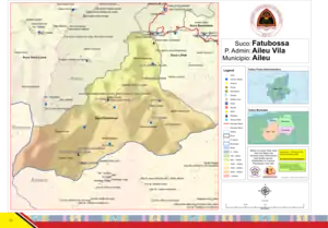 Karte des Sucos Fatubossa Karte des Sucos Fatubossa | |||
| Basisdaten | |||
| Staat | Osttimor | ||
| Aileu | |||
| Verwaltungsamt | Aileu | ||
| Suco | Fatubossa | ||
| Aldeia | Hoholete | ||
| Höhe | 1675 m | ||
Geographie
Hoholete liegt im Zentrum der Aldeia Hoholete auf einer Meereshöhe von 1675 m. Das Dorf liegt am Ende der Straße, die vom Ort Fatubossa (Aldeia Fatubossa) im Norden über Iolau (Aldeia Hoholete) nach Hoholete führt. Die Häuser des Dorfes stehen einzeln oder in kleinen Gruppen verstreut. Im Süden steht die Grundschule Hoholete (portugiesisch Escola Básico Hoholete).[1]
Iolau schließt sich Hoholete direkt im Norden an. Im Südosten befindet sich der Weiler Urbuarema (Aldeia Hoholete), im Nordosten das Dorf Liclaucana (Aldeia Liclaucana).[1]
Einzelnachweise
- Direcção-Geral de Estatística: Atlas der Gemeinde Aileu, abgerufen am 21. März 2021.
This article is issued from Wikipedia. The text is licensed under Creative Commons - Attribution - Sharealike. The authors of the article are listed here. Additional terms may apply for the media files, click on images to show image meta data.