Grand Anse (Mahé)
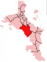
Grand Anse ist ein Verwaltungs-Distrikt der Seychellen auf der Insel Mahé.
| Bezirk der Seychellen Grand Anse | |
|---|---|
 Lage |
 |
| Geographische Lage: | |
| Insel: | Mahé (Seychellen) |
| Fläche: | 15,4 km² |
| Einwohner: | 3833[1] |
| Bevölkerungsdichte: | Einwohner/km² |
| Motto: | Friendship and Unity for Progress |
| ISO 3166-2 code | SC-13 |
Geographie
_-_de_-_colored.svg.png.webp)
Distrikte der Seychellen
Der Distrikt liegt an der Südküste von Mahé. Er wird begrenzt von den Distrikten Port Glaud im Westen, Plaisance (Seychellen), Les Mamelles, Cascade und Anse Boileau. Zu Bel Air besteht eine Punktuelle Verbindung an der Nordecke des Distrikts.
Die Hauptsiedlungen im Distrikt sind Souvenir im Inselzentrum und Grand Anse Village an der Küste. Nach Nordosten erstreckt sich der Distrikt bis zum Gipfel des Mount Harrison (566 m). Im Distrikt verlaufen auch die beiden Flüsse Rivière Seche und Rivière Dauban, die kurz vor der Mündung im Osten der Grand Anse zusammenfließen.[2]
Der Distrikt hat den ISO 3166-2-Code SC-13.[3]
Einzelnachweise
- (2009 Fortschreibung des Zensus 2002) Government of the Seychelles: Statistical Bulletin, District Population 2007 and Population estimates 2008–2009. National Statistics Bureau, Victoria 2009. (Seite nicht mehr abrufbar, Suche in Webarchiven) Info: Der Link wurde automatisch als defekt markiert. Bitte prüfe den Link gemäß Anleitung und entferne dann diesen Hinweis.
- geonames.org.
- iso.org.
This article is issued from Wikipedia. The text is licensed under Creative Commons - Attribution - Sharealike. The authors of the article are listed here. Additional terms may apply for the media files, click on images to show image meta data.