Furneaux-Gruppe
Die Furneaux-Gruppe (englisch Furneaux Group) ist eine aus etwa 60 Inseln bestehende Inselgruppe am Ostende der Bass-Straße. Die Inseln zählen zum australischen Bundesstaat Tasmanien.
| Furneaux-Gruppe | ||
|---|---|---|
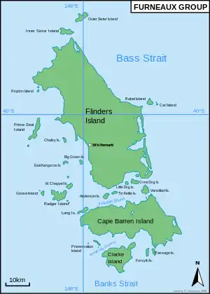 Karte der Furneaux-Gruppe | ||
| Gewässer | Bass-Straße | |
| Geographische Lage | 40° 10′ S, 148° 5′ O | |
| ||
| Anzahl der Inseln | ca. 60 | |
| Hauptinsel | Flinders Island | |
| Gesamte Landfläche | 2010 km² | |
| Einwohner | 850 | |
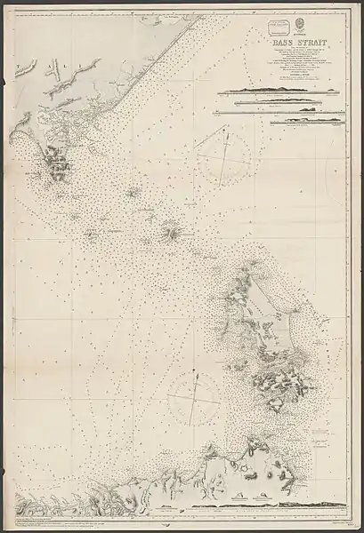 Seekarte der östlichen Bass-Straße mit der Furneaux-Gruppe | ||
Die Inseln wurden nach dem britischen Entdecker Tobias Furneaux benannt, der das Gebiet 1773 erforschte. Die Inseln selbst wurden im Februar 1798 von Matthew Flinders erforscht.
Die größten Inseln der Gruppe sind Flinders Island, Cape Barren Island und Clarke Island. Auf Flinders Island befinden sich 5 Siedlungen: Killiecrankie, Emita, Lady Barron, Cape Barren Island und Whitemark. Letzteres ist das Gemeindeverwaltungszentrum der Flinders local government area, das aus den Inseln gebildet wird. Diese Orte haben 800 Einwohner, die Gesamtbevölkerung des Archipels beträgt um 850 Einwohner.
Die historisch bedeutsame Aboriginal Dolly Dalrymple wurde auf den Inseln geboren.[1]
Die New-Year-Island-Gruppe mit der Hauptinsel King Island am Westende der Bass-Straße sowie die nordwestlich der Furneaux-Gruppe in Richtung Australien gelegene Kent-Gruppe werden nicht der Inselgruppe zugerechnet.
Inseln
![]() Karte mit allen Koordinaten: OSM | WikiMap
Karte mit allen Koordinaten: OSM | WikiMap
Unvollständige Liste der Inseln der Furneaux-Gruppe (vorsortiert von Norden nach Süden):
| Inselname | Aliasname | Koordinaten | Fläche | Einwohner | Anmerkung |
|---|---|---|---|---|---|
| Outer Sister Island | North Sister Island | 39° 39′ S, 147° 59′ O | 5,5 | - | |
| Shag Reef | 39° 40′ S, 148° 00′ O | 0,02 | - | ||
| Craggy Island | 39° 41′ S, 147° 41′ O | 0,3 | - | ||
| Inner Sister Island | 39° 42′ S, 147° 55′ O | 7,8 | - | ||
| Bass Pyramid | 39° 49′ S, 147° 15′ O | 0,0001 | - | ||
| Little Island | 39° 49′ S, 147° 49′ O | 0,03 | - | ||
| Sentinel Island | 39° 50′ S, 147° 46′ O | 0,07 | - | ||
| Little Sentinel Island | 39° 51′ S, 147° 46′ O | 0,01 | - | ||
| Roydon Island | 39° 54′ S, 147° 46′ O | 0,4 | - | ||
| North Pasco Island | 39° 55′ S, 147° 47′ O | 0,38 | - | ||
| Middle Pasco Islands | 39° 56′ S, 147° 46′ O | 0,8 | - | Inselgruppe | |
| Babel Island | 39° 57′ S, 148° 20′ O | 4,5 | - | ||
| Cat Island | Carl Island | 39° 57′ S, 148° 21′ O | 0,4 | - | |
| South Pasco Island | 39° 57′ S, 147° 46′ O | 0,38 | - | ||
| Storehouse Island | 39° 57′ S, 148° 22′ O | 0,23 | - | ||
| Flinders Island | 40° 00′ S, 148° 02′ O | 1330 | 776 | ||
| Wybalenna Island | 40° 02′ S, 147° 51′ O | 0,17 | - | ||
| Prime Seal Island | 40° 04′ S, 147° 45′ O | 13,4 | - | ||
| Chalky Island | 40° 06′ S, 147° 53′ O | 0,44 | - | ||
| Mile Island | 40° 07′ S, 147° 55′ O | 0,04 | - | ||
| Isabella Island | 40° 08′ S, 147° 57′ O | 1,14 | - | ||
| Low Islands | Low Islets | 40° 08′ S, 147° 44′ O | 0,002 | - | Inselgruppe |
| Little Chalky Island | 40° 08′ S, 147° 54′ O | 0,005 | - | ||
| Big Green Island | 40° 11′ S, 147° 59′ O | 1,4 | - | ||
| East Kangaroo Island | 40° 11′ S, 147° 54′ O | 1,7 | - | ||
| Samphire Island | 40° 13′ S, 148° 13′ O | 0,33 | - | ||
| Little Green Island | 40° 14′ S, 148° 15′ O | 0,87 | - | ||
| Great Dog Island | 40° 15′ S, 148° 15′ O | 3,75 | - | ||
| Little Dog Island | 40° 15′ S, 148° 12′ O | 0,83 | - | ||
| Briggs Island | 40° 15′ S, 148° 17′ O | 0,034 | - | ||
| South East Great Dog Island | 40° 15′ S, 148° 16′ O | 0,006 | - | ||
| North West Mount Chappell Island | 40° 16′ S, 147° 55′ O | 0,03 | - | Chappell-Inseln | |
| Mount Chappell Island | Chappell Island | 40° 16′ S, 147° 55′ O | 3,38 | - | Chappell-Inseln |
| Vansittart Island | Gun Carriage Island | 40° 17′ S, 148° 18′ O | 8 | - | |
| Oyster Rocks | 40° 17′ S, 148° 04′ O | 0,06 | - | Inselgruppe | |
| Little Anderson Island | Little Woody Island | 40° 17′ S, 148° 07′ O | 0,13 | - | Anderson-Inseln |
| Mid Woody Island | 40° 18′ S, 148° 07′ O | 0,0066 | - | Anderson-Inseln | |
| Little Goose Island | 40° 18′ S, 147° 47′ O | 0,04 | - | Chappell-Inseln | |
| Tin Kettle Island | 40° 18′ S, 148° 09′ O | 1,76 | - | Anderson-Inseln | |
| Inner Little Goose Island | 40° 18′ S, 147° 47′ O | 0,01 | - | Chappell-Inseln | |
| Pelican Island | 40° 18′ S, 148° 19′ O | 0,068 | - | ||
| Little Badger Island | 40° 18′ S, 147° 55′ O | 0,025 | - | Chappell-Inseln | |
| Anderson Island | Woody Island | 40° 18′ S, 148° 06′ O | 1,66 | - | Anderson-Inseln |
| Goose Island | 40° 18′ S, 147° 48′ O | 1,09 | - | Chappell-Inseln | |
| Puncheon Island | 40° 18′ S, 148° 19′ O | 0,1756 | - | ||
| Badger Island | 40° 19′ S, 147° 52′ O | 12,42 | - | Chappell-Inseln | |
| Beagle Island | 40° 20′ S, 147° 55′ O | 0,12 | - | Chappell-Inseln | |
| Doughboy Island | 40° 20′ S, 148° 03′ O | 0,3 | - | ||
| Long Island | 40° 22′ S, 148° 00′ O | 3,13 | - | ||
| Double Rock | 40° 22′ S, 147° 53′ O | 0,0001 | - | Chappell-Inseln, 2 Inseln | |
| Boxen Island | 40° 23′ S, 147° 54′ O | 0,07 | - | Chappell-Inseln | |
| Cape Barren Island | 40° 24′ S, 148° 14′ O | 464 | 67 | ||
| Big Black Reef | 40° 24′ S, 147° 58′ O | 0,0054 | - | ||
| Preservation Island | 40° 29′ S, 148° 04′ O | 2,07 | - | ||
| Night Island | 40° 29′ S, 148° 01′ O | 0,0259 | - | ||
| Rum Island | 40° 30′ S, 148° 04′ O | 0,135 | - | ||
| Passage Island | 40° 30′ S, 148° 20′ O | 2,53 | - | ||
| Forsyth Island | 40° 31′ S, 148° 19′ O | 1,67 | - | ||
| Clarke Island | 40° 32′ S, 148° 10′ O | 82 | 6 | ||
| Spike Island | 40° 33′ S, 148° 07′ O | 0,06 | - |
Quellen
- Ian McFarlane, Dalrymple, Dolly (c. 1808 - 1864), Australian Dictionary of Biography, Supplementary Volume, Melbourne University Press, 2005, p. 94.
Literatur
- Cumpston, J. S. First visitors to Bass Strait Canberra : Roebuck Society, 1973. ISBN 0-9500858-8-X Roebuck Society publication no. 7.
Weblinks
- Website des Archipels (englisch)
- Touristikseite über Flinders Island (englisch)
- Vogelwelt der Furneaux-Inseln (englisch)
- Wracks auf dem Gebiet der Inselgruppe (englisch)