Folly Island (Neuseeland)
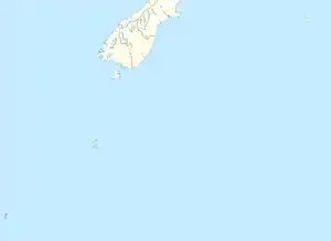
Folly Island ist eine der Campbell-Inseln, einer Gruppe kleiner subarktischer Inseln vor der zu Neuseeland gehörenden Insel Campbell Island im südlichen Pazifischen Ozean.
| Folly Island | ||
|---|---|---|
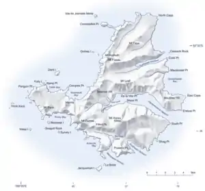 Karte von Campbell Island mit Folly Island im Westen | ||
| Gewässer | Pazifischer Ozean | |
| Geographische Lage | 52° 32′ S, 169° 3′ O | |
| ||
| Länge | 460 m | |
| Breite | 225 m | |
| Höchste Erhebung | > 60 m | |
| Einwohner | unbewohnt | |
Geographie
Die 460 m lange und bis zu 225 m breite Insel befindet sich 30 m vom Ramp Point an der südwestlichen Landzunge von Campbell Island entfernt.[1] Sie erhebt sich mit ihren steil abfallenden Felsen bis über 60 m aus dem Meer.[2]
Geologie
Folly Island besteht aus Basalt-Gestein. Die Insel entstand durch Erosion und war ursprünglich Teil des ehemaligen Vulkans, der die Insel Campbell Island im späten Känozoikum bildete.[3]
Flora und Fauna
Die Insel ist unter anderem mit Tussock (Poa litorosa und Poa foliosa) bewachsen.[4] Büsche und Bäume kommen nicht vor. Ein spezielles Gras, als Chionochloa antarctica bekannt, kommt auf der Insel vermutlich als ursprüngliche und unberührte Form vor.[4]
Bei einer Erkundung der Insel im Jahr 1976 fand man auf der Insel lebende Ratten vor.[5]
Weltnaturerbe
Als Teil von Campbell Island zählt die Insel mit zum im Jahr 1998 anerkannten UNESCO-Weltnaturerbe, in dem die subarktischen Inselgruppen The Snares, Bounty Islands, Antipodes Islands, Auckland Islands und die Insel Campbell Island den Schutzstatus ausgesprochen bekommen haben.[6]
Literatur
- Patrick Marshall: New Zealand and adjacent islands. VII Abschnitt 1. Carl Winter's Universitätsbuchhandlung, Heidelberg 1912, B. Outlying Islands of New Zealand (englisch, Online [PDF; 6,7 MB; abgerufen am 8. Juni 2018]).
- M. N. Foggo, Colin D. Meurk: Notes on a Visit to Jacquemart Island in the Campbell Island Group. In: New Zealand Journal of Ecology. Vol. 4, 1981, S. 29–32 (englisch, Online [PDF; 473 kB; abgerufen am 7. Juni 2018]).
Weblinks
- Campbell Island. (JPG 4,0 MB) Land Information New Zealand, abgerufen am 7. Juni 2018 (englisch, Detaillierte topografische Karte von Campbell Island mit seinen kleinen Nachbarinsel und Felseninseln).
Einzelnachweise
- Koordinaten und Längenbestimmungen wurden mittels Goggle Earth Pro Version 7.3.1.4507 am 07. Juni 2018 vorgenommen
- Campbell Island. (JPG 4,0 MB) Land Information New Zealand, abgerufen am 7. Juni 2018 (englisch, Detaillierte topografische Karte von Campbell Island mit seinen kleinen Nachbarinsel und Felseninseln).
- Marshall: New Zealand and adjacent islands. 1912, S. 62–64.
- Foggo, Meurk: Notes on a Visit to Jacquemart Island in the Campbell Island Group. 1981, S. 30.
- Foggo, Meurk: Notes on a Visit to Jacquemart Island in the Campbell Island Group. 1981, S. 29.
- New Zealand Sub-Antarctic Islands - Description. UNESCO, 1998, abgerufen am 7. Juni 2018 (englisch).