Firth River
Der Firth River ist ein Wildfluss im Ivvavik-Nationalpark in Yukon (Kanada).
| Firth River | ||
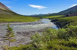 Sluice Rapids am Firth River im Ivvavik-Nationalpark Sluice Rapids am Firth River im Ivvavik-Nationalpark | ||
| Daten | ||
| Gewässerkennzahl | US: 1402078 | |
| Lage | North Slope Borough in Alaska (USA), Yukon-Territorium (Kanada) | |
| Flusssystem | Firth River | |
| Quellgebiet | Brooks Range im North Slope Borough in Alaska 68° 28′ 40″ N, 141° 53′ 31″ W | |
| Quellhöhe | ca. 3500 m | |
| Mündung | im Yukon-Territorium in die Beaufortsee 69° 33′ 0″ N, 139° 30′ 0″ W | |
| Mündungshöhe | 0 m[1] | |
| Höhenunterschied | ca. 3500 m | |
| Sohlgefälle | ca. 19 ‰ | |
| Länge | ca. 180 km | |
| Einzugsgebiet | ca. 6070 km² | |
| Abfluss am Pegel in Mündungsnähe[2] AEo: 5710 km² Lage: 28 km oberhalb der Mündung |
MQ 1972/2000 Mq 1972/2000 |
36,7 m³/s 6,4 l/(s km²) |
Der Fluss entspringt in der Brooks Range in Alaska, mündet südwestlich von Herschel Island in die Beaufortsee und gehört somit zum Einzugsgebiet des Arktischen Ozeans. Der Fluss ist ein beliebtes Ziel für Kajak- und Raftingtouren.
Weblinks
Commons: Firth River – Sammlung von Bildern, Videos und Audiodateien
Einzelnachweise
- Firth River im Geographic Names Information System des United States Geological Survey
- Firth River am Pegel FIRTH RIVER NEAR THE MOUTH – hydrographische Daten bei R-ArcticNET
This article is issued from Wikipedia. The text is licensed under Creative Commons - Attribution - Sharealike. The authors of the article are listed here. Additional terms may apply for the media files, click on images to show image meta data.