Fatukoan (Holpilat)
Fatukoan ist ein osttimoresisches Dorf im Suco Holpilat (Verwaltungsamt Maucatar, Gemeinde Cova Lima).[1] Bis 2015 war Fatukaon noch Teil des Sucos Debos (Verwaltungsamt Suai).[2] Fatukoan liegt auf einer Meereshöhe von 111 m,[3] nördlich des Flusses Tafara an der südlichen Küstenstraße Osttimors, die hier etwas weiter landeinwärts verläuft.[2]
| Fatukoan | |||
|---|---|---|---|
| |||
| Koordinaten | 9° 21′ S, 125° 12′ O | ||
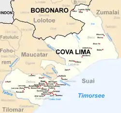 Fatukoan auf einer Karte von Suai (vor 2015) Fatukoan auf einer Karte von Suai (vor 2015) | |||
| Basisdaten | |||
| Staat | Osttimor | ||
| Cova Lima | |||
| Verwaltungsamt | Maucatar | ||
| Suco | Holpilat | ||
| Höhe | 111 m | ||
Einzelnachweise
- Ministerium für Staatsverwaltung und Territorialmanagement: Karte des Verwaltungsamts Maucatar.
- Timor-Leste GIS-Portal (Memento vom 30. Juni 2007 im Internet Archive)
- Fallingrain.com: Directory of Cities, Towns, and Regions in East Timor
This article is issued from Wikipedia. The text is licensed under Creative Commons - Attribution - Sharealike. The authors of the article are listed here. Additional terms may apply for the media files, click on images to show image meta data.