Faadhippolhu-Atoll
Das Faadhippolhu-Atoll (auch Fadiffolu, Dhivehi ފާދިއްޕޮޅު) ist ein Atoll der Malediven. Es liegt nördlich des Nord-Malé-Atolls und ist deckungsgleich mit dem Gebiet des Verwaltungs-Atoll Lhaviyani.
| Faadhippolhu-Atoll (Lhaviyani) | ||
|---|---|---|
.JPG.webp) NASA-Sat.-Bild des Faadhippolhu Atolls | ||
| Gewässer | Lakkadivensee (Indischer Ozean) | |
| Archipel | Malediven | |
| Geographische Lage | 5° 20′ N, 73° 30′ O | |
| ||
| Anzahl der Inseln | 55[1] | |
| Hauptinsel | Naifaru | |
| Länge | 36 km | |
| Breite | 24 km | |
| Landfläche | 7,2 km² | |
| Gesamtfläche | 701,46 km² | |
| Einwohner | 9190 (2006[2]) | |
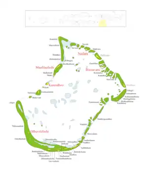 Karte des Faadhippolhu-Atolls | ||

Mit einer Gesamtfläche von 701,46 km² ist das Faadhippolhu-Atoll das zwölftgrößte Atoll der Malediven. Die aggregierte Landfläche der Inseln beträgt dagegen nur 7,20 km² oder etwa ein Prozent der Gesamtfläche.[3]
Geographie
.jpg.webp)
Von den 55[1] Inseln des Faadhippolhu-Atolls sind fünf bewohnt. Es sind dies Hinnavaru, Kurendhoo, Maafilaafushi, Naifaru und Olhuvelifushi.
Weblinks
Einzelnachweise
- The President's Office (Maledives): Isles - Lhaviyani. In: isles.gov.mv. 2022, abgerufen am 14. Februar 2022.
- Statistical Yearbook of the Maldives 2011, statisticsmaldives.gov.mv
- National Adaptation Programme of Action (NAPA). (PDF; 6,2 MB) Ministry of Environment, Energy and Water
von Nord nach Süd:
Ihavandhippolhu | Thiladhunmathi-Miladummadulhu | Maamakunudhoo | Alifushi | Nord-Maalhosmadulu | Fasdhūtherē | Süd-Maalhosmadulu | Faadhippolhu | Goidhoo | Kaashidhoo | Gaafaru | Nord-Malé | Süd-Malé | Thoddoo | Rasdhoo | Ari | Felidhu | Vattaru | Mulaku | Nord-Nilandhe | Süd-Nilandhe | Kolhumadulu | Haddhunmathi | Huvadhu | Fuvahmulah | Addu