Distrikte in Neuseeland
Distrikte (engl.: Territorial Authority) bilden in Neuseeland die zweite Stufe der Verwaltungsgliederung des Landes.
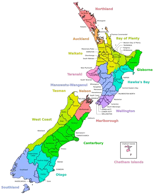
Während sich auf der ersten Stufe der Verwaltungsgliederung elf Regionen und sechs Unitary Authorities befinden, gibt es auf der zweiten Stufe insgesamt 67 Territorial Authorities, wovon 13 Städte einen City Council (Stadtrat) und 54 Distrikte einen District Council (Distriktrat) besitzen. Von ihnen nehmen zwei Städte (Auckland und Nelson City) und vier Distrikte (Gisborne District, Tasman District, Marlborough District und das Chatham Islands Territory) neben der Stadt- bzw. Distriktverwaltung auch Aufgaben einer Regionsverwaltung wahr, sind also Unitary Authorities. Die Distrikte unterliegen nicht der Verwaltung der Regionen. Dadurch gibt es sieben Distrikte, die in mindestens zwei Regionen liegen, sowie einen (Taupo District), der sich gar auf vier Regionen verteilt.
Territorial Authorities
Nordinsel
- Thames-Coromandel District
- Hauraki District
- Waikato District
- Matamata-Piako District
- Hamilton City
- Waipa District
- South Waikato District
- Otorohanga District
- Rotorua Lakes (teilweise, ca. 40 %)
- Waitomo District (teilweise, ca. 95 %)
- Taupo District (teilweise, ca. 75 %)
- Western Bay of Plenty District
- Tauranga City
- Opotiki District
- Whakatāne District
- Rotorua Lakes (teilweise, ca. 60 %)
- Kawerau District
- Taupo District (teilweise, ca. 10 %)
- Wairoa District
- Taupo District (teilweise, ca. 10 %)
- Hastings District
- Napier City
- Central Hawke’s Bay District
- Rangitikei District (teilweise, ca. 10 %)
- New Plymouth District
- Stratford District (teilweise, ca. 70 %)
- South Taranaki District
- Manawatu-Wanganui Region (seit 2003 Trade Name: Horizons Region)
- Taupo District (teilweise, ca. 5 %)
- Waitomo District (teilweise, ca. 5 %)
- Ruapehu District
- Stratford District (teilweise, ca. 30 %)
- Rangitikei District (teilweise, ca. 90 %)
- Whanganui District
- Manawatu District
- Palmerston North City
- Tararua District (teilweise, ca. 97 %)
- Horowhenua District
- Wellington Region (auch Greater Wellington)
Südinsel
- Kaikoura District
- Hurunui District
- Selwyn District
- Waimakariri District
- Christchurch City
- Ashburton District
- Mackenzie District
- Timaru District
- Waitaki District (teilweise, ca. 55 %)
- Waimate District
- Queenstown-Lakes District
- Central Otago District
- Waitaki District (teilweise, ca. 45 %)
- Dunedin City
- Clutha District
- Southland District (zu diesem Distrikt gehört auch Stewart Island)
- Gore District
- Invercargill City
Chatham-Inseln
Sonstige Gebiete
Die restlichen Staatsgebiete, wie zum Beispiel Whakaari / White Island, Motiti Island oder Mayor Island, unterstehen direkt dem "Minister of Local Government".
Tokelau, die Cookinseln und Niue verwalten sich relativ autonom, wobei Tokelau nicht nur mit Neuseeland assoziiert ist, sondern ein integraler Teil Neuseelands ist.
Geschichte
Im Jahr 1989 entstanden im Zuge der Verwaltungsreformen erst viele der heute existierenden 74 Distrikte. Seitdem traten einige Veränderungen auf:
- 1991: Invercargill wurde wieder zu einem City Council ausgerufen.
- 1992: Die damalige Region Nelson-Marlborough wurde aufgelöst und die drei Unitary Authorities Tasman, Nelson und Marlborough wurden gegründet.
- 1995: Das Chatham Islands Council wurde in einen Distrikt mit den Funktionen einer Region umgewandelt.
- 2004: Tauranga wurde am 1. März wieder zur Stadt (City Council) ausgerufen.
- 2006: Im Zuge einer Volksabstimmung wurde am 6. März das Banks Peninsula District Council aufgelöst. Das Gebiet gehört seitdem zum Christchurch City Council.
Weblinks
- localcouncils.govt.nz (unterhalten vom neuseeländischen Innenministerium)
- Der "Minister for Local Government"