Distrikt (Malawi)
Malawi ist in 32 Distrikte, darunter vier Städte mit Distriktstatus (Mzuzu, Lilongwe, Zomba und Blantyre) unterteilt, die zu drei Regionen gehören:[1]
| Nr. | Regionen und Distrikte | Fläche (km²) |
Bevölkerung (in 1000) | Bevölkerungsdichte (pro km²) | ||||
|---|---|---|---|---|---|---|---|---|
| 1998 | 2008 | 2018 | 1998 | 2008 | 2018 | |||
| Northern Region | 27.131 | 1.234 | 1.709 | 2.287 | 46 | 62 | 84 | |
| 1 | Chitipa | 4.334 | 127 | 179 | 235 | 30 | 41 | 54 |
| 2 | Karonga | 3.416 | 195 | 270 | 365 | 57 | 77 | 107 |
| 3 | Rumphi | 4.560 | 128 | 172 | 229 | 27 | 37 | 50 |
| 4 | Mzimba | 10.473 | 524 | 728 | 936 | 50 | 69 | 89 |
| 5 | Mzuzu | 146 | 87 | 134 | 221 | 1.812 | 2.791 | 1.516 |
| 6 | Nkhata Bay | 4.182 | 165 | 216 | 286 | 40 | 52 | 68 |
| 7 | Likoma | 20 | 8 | 10 | 15 | 449 | 524 | 710 |
| Central Region | 35.641 | 4.066 | 5.510 | 7.526 | 114 | 154 | 211 | |
| 8 | Kasungu | 8.017 | 481 | 628 | 843 | 60 | 78 | 105 |
| 9 | Nkhotakota | 4.338 | 230 | 304 | 396 | 54 | 69 | 91 |
| 10 | Ntchisi | 1.709 | 168 | 225 | 317 | 98 | 130 | 185 |
| 11 | Dowa | 3.077 | 411 | 559 | 773 | 134 | 182 | 251 |
| 12 | Mchinji | 3.131 | 325 | 457 | 602 | 104 | 145 | 192 |
| 13 | Lilongwe | 403 | 441 | 674 | 989 | 1.093 | 1.660 | 2.453 |
| 14 | Lilongwe Rural | 5.808 | 1.346 | 1.231 | 1.638 | 232 | 212 | 282 |
| 15 | Salima | 2.151 | 248 | 338 | 478 | 115 | 157 | 222 |
| 16 | Dedza | 3.754 | 487 | 624 | 831 | 130 | 167 | 221 |
| 17 | Dedza | 3.251 | 371 | 472 | 660 | 114 | 145 | 203 |
| Southern Region | 31.780 | 4.634 | 5.858 | 7.751 | 146 | 184 | 244 | |
| 18 | Mangochi | 6.729 | 610 | 797 | 1.149 | 97 | 118 | 171 |
| 19 | Balaka | 2.142 | 253 | 317 | 438 | 115 | 148 | 205 |
| 20 | Machinga | 3.582 | 370 | 491 | 735 | 103 | 138 | 205 |
| 21 | Neno | 1.561 | 75 | 107 | 138 | 51 | 69 | 89 |
| 22 | Mwanza | 756 | 63 | 93 | 131 | 77 | 122 | 173 |
| 23 | Blantyre Rural | 1.785 | 307 | 341 | 451 | 172 | 190 | 253 |
| 24 | Chikwawa | 4.878 | 357 | 435 | 565 | 73 | 90 | 116 |
| 25 | Blantyre | 240 | 502 | 661 | 800 | 2.282 | 2.698 | 3.328 |
| 26 | Zomba | 42 | 66 | 88 | 105 | 1.690 | 1.949 | 2.511 |
| 27 | Zomba Rural | 2.363 | 481 | 580 | 747 | 189 | 245 | 316 |
| 28 | Chiradzulu | 761 | 236 | 289 | 357 | 308 | 378 | 469 |
| 29 | Phalombe | 1.323 | 232 | 313 | 430 | 175 | 238 | 325 |
| 30 | Mulanje | 2.005 | 428 | 521 | 684 | 208 | 261 | 341 |
| 31 | Thyolo | 1.666 | 459 | 587 | 722 | 268 | 354 | 433 |
| 32 | Nsanje | 1.945 | 195 | 238 | 299 | 100 | 124 | 154 |
| Malawi | 94.552 | 9.934 | 13.077 | 17.564 | 105 | 138 | 186 | |
| Quelle: Volkszählung 2018[1] | ||||||||
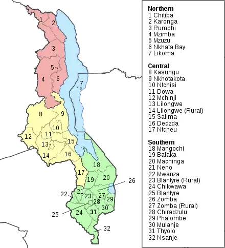
Die Grenzen der 32 Distrikte Malawis
Quellen
- Statistical Yearbook > 2018 Statistical Yearbook. Nationale Statistikbehörde Malawis, abgerufen am 23. Mai 2021 (englisch).
This article is issued from Wikipedia. The text is licensed under Creative Commons - Attribution - Sharealike. The authors of the article are listed here. Additional terms may apply for the media files, click on images to show image meta data.