Discovery Bay (Südliche Shetlandinseln)
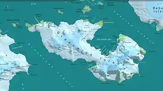
Die Discovery Bay (englisch für Entdeckungsbucht, in Chile Bahía Chile) ist eine Bucht von 5 km Länge und 3 km Breite an der Ostküste von Greenwich Island im Archipel der subantarktischen Inselgruppe Südliche Shetlandinseln.
| Discovery Bay | ||
|---|---|---|
 Karte von Greenwich Island mit der Discovery Bay Karte von Greenwich Island mit der Discovery Bay | ||
| Gewässer | English Strait | |
| Landmasse | Greenwich Island, Südliche Shetlandinseln | |
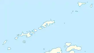
| Geographische Lage | 62° 28′ 59″ S, 59° 42′ 58″ W | |
| ||
| Inseln | Basso Island, Bonert Rock, Canales Island, Islotes Catalán, Coloma Island, Cruz Rock, Dovizio Rock, Fuente Rock, Honores Rock, Joliette Rock, Skarmeta Rocks, Tenorio Rock, Valdebenito Rock, Vidal Rock | |
| Zuflüsse | Fuerza-Aérea-Gletscher, Jorquera-Gletscher, Traub-Gletscher | |
Bekannt ist die Bucht durch Robbenjäger mindestens seit 1821. Teilnehmer der britischen Discovery Investigations kartierten und benannten sie im Jahr 1935.
Weblinks
- Discovery Bay im Geographic Names Information System des United States Geological Survey (englisch)
- Discovery Bay auf geographic.org (englisch)
This article is issued from Wikipedia. The text is licensed under Creative Commons - Attribution - Sharealike. The authors of the article are listed here. Additional terms may apply for the media files, click on images to show image meta data.
