Curtis-Gruppe
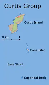
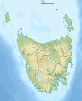
Die Curtis-Gruppe (englisch Curtis Group)[1] ist eine unbewohnte Inselgruppe in der nördlichen Bass-Straße etwa 40 km vor der Südspitze des australischen Festlands. Die Inseln gehören zum australischen Bundesstaat Tasmania.
| Curtis-Gruppe | ||
|---|---|---|
 Karte der Inselgruppe | ||
| Gewässer | Bass-Straße | |
| Geographische Lage | 39° 29′ S, 146° 38′ O | |
| ||
| Anzahl der Inseln | 3 | |
| Hauptinsel | Curtis Island | |
| Gesamte Landfläche | 1,49 km² | |
| Einwohner | unbewohnt | |
Die Inselgruppe besteht aus drei Inseln und zahlreichen Einzelfelsen. Hauptinsel ist das bis 220 m hohe und dürftig bewachsene Curtis Island im Norden. Die 90 m hohe Felsinsel Sugarloaf Rock bildet die südlichste Insel der Gruppe.
Liste der Inseln
![]() Karte mit allen Koordinaten: OSM | WikiMap
Karte mit allen Koordinaten: OSM | WikiMap
| Inselname | Aliasname | Koordinaten | Fläche | Einwohner |
|---|---|---|---|---|
| Curtis Island | 39° 28′ S, 146° 39′ O | 1,44 | - | |
| Cone Island | Cone Islet | 39° 30′ S, 146° 40′ O | 0,04 | - |
| Sugarloaf Rock | 39° 31′ S, 146° 39′ O | 0,01 | - | |
Einzelnachweise
- Curtis Group. In: geonames.org. Abgerufen am 31. Mai 2020 (englisch).
This article is issued from Wikipedia. The text is licensed under Creative Commons - Attribution - Sharealike. The authors of the article are listed here. Additional terms may apply for the media files, click on images to show image meta data.