Crim Rocks
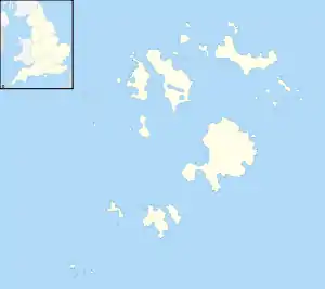
Die Crim Rocks (kornisch: An Creeban) sind eine unbewohnte Inselgruppe im äußersten Westen der Scilly-Inseln. Die Eilande befinden sich 2,4 km nordnordwestlich von Bishop Rock und 400 m südwestlich von Zantman’s Rock, und bilden die westlichste Landmasse Englands. Der Name Crim stammt wahrscheinlich vom walisischen Crimp ab, was so viel wie „Felsgrat“ bzw. „Felsvorsprung“ bedeutet.[1]
| Crim Rocks | ||
|---|---|---|
 Peaked Rock, westlichster Punkt von England | ||
| Gewässer | Keltische See | |
| Archipel | Scilly-Inseln | |
| Geographische Lage | 49° 54′ N, 6° 27′ W | |
| ||
| Anzahl der Inseln | 2 | |
| Hauptinsel | Peaked Rock | |
| Gesamte Landfläche | 0,000.13 km² | |
| Einwohner | unbewohnt | |
Karte der Scilly-Inseln (1946) mit Crim Rocks am linken Rand mit Crim Rocks am linken Rand | ||
Die Inselgruppe gehört verwaltungsmäßig zur Civil Parish St._Agnes_(Scilly-Inseln) im Südwesten der Scilly-Inseln.
Weblinks
Literatur
- Craig Weatherhill: Cornish Placenames and Language. Wilmslow: Sigma Leisure 1995 ISBN 1850584621
Einzelnachweise
- Great Britain, Hydrographic Dept, (1891), Sailing directions for the west coast of England, page 26
This article is issued from Wikipedia. The text is licensed under Creative Commons - Attribution - Sharealike. The authors of the article are listed here. Additional terms may apply for the media files, click on images to show image meta data.
