Costa Azul (Uruguay)
| Costa Azul | ||
|---|---|---|
|
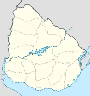
Costa Azul auf der Karte von Uruguay | ||
| Basisdaten | ||
| Staat | Uruguay | |
| Departamento | Canelones | |
| Einwohner | 965 (2011) | |
| Detaildaten | ||
| Gewässer | Río de la Plata | |
| Postleitzahl | 16202[1] | |
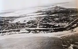 Luftaufnahme von Costa Azul aus dem Jahr 1945 | ||
Costa Azul ist eine Ortschaft in Uruguay.
Geographie
Costa Azul befindet sich auf dem Gebiet des Departamento Canelones in dessen Sektor 8. Der Ort liegt an der Küste des Río de la Plata zwischen dem östlich angrenzenden Bello Horizonte und dem im Westen die Grenze zum Nachbarort La Floresta bildenden Arroyo Sarandí.
Infrastruktur
Der Ort liegt an der Ruta Interbalnearia, etwa an deren Kilometerpunkt 56.
Einwohner
Die Einwohnerzahl von Costa Azul beträgt 965 (Stand: 2011).[2]
| Jahr | Einwohner |
|---|---|
| 1963 | 271 |
| 1975 | 456 |
| 1985 | 554 |
| 1996 | 759 |
| 2004 | 826 |
| 2011 | 965 |
Weblinks
- Stadtplan von Costa Azul (PDF; 150 kB)
Einzelnachweise
- Códigos Postales del Interior
- Statistische Daten des Instituto Nacional de Estadística de Uruguay, abgerufen am 4. Juli 2013
- Statistische Daten des Instituto Nacional de Estadística de Uruguay 1963–1996 (DOC; 176 kB)
- Statistische Daten des Instituto Nacional de Estadística de Uruguay – Stand 2004 (MS Excel; 75 kB), abgerufen am 24. Oktober 2010
This article is issued from Wikipedia. The text is licensed under Creative Commons - Attribution - Sharealike. The authors of the article are listed here. Additional terms may apply for the media files, click on images to show image meta data.