Coltishall
Coltishall ist ein Dorf mit 1405 Einwohnern[1] am Fluss Bure, im Westen von Wroxham, in Norfolk gelegen,[2] innerhalb der Norfolk Broads.
| Coltishall | |||
|---|---|---|---|
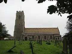 St John the Baptist, Coltishall | |||
| Koordinaten | 52° 44′ N, 1° 22′ O | ||
| OS National Grid | TG271197 | ||
| |||
| Traditionelle Grafschaft | Norfolk | ||
| Einwohner | 1405 (Stand: 2001) | ||
| Fläche | 7,27 km² (2,81 mi²) | ||
| Bevölkerungsdichte | 193,3 Einwohner/km² | ||
| Verwaltung | |||
| Post town | NORWICH | ||
| Postleitzahlenabschnitt | NR12 | ||
| Landesteil | England | ||
| Region | East of England | ||
| Shire county | Norfolk | ||
| District | Broadland | ||
| Civil Parish | Coltishall | ||
Coltishall wurde im Domesday Book erwähnt. Das Dorf war 250 Jahre lang ein Zentrum der Malzindustrie. Viele Norfolk Wherrys (Handelsschiffe) wurde in dem Dorf gebaut. Zwischen 1779 und 1912 war es möglich, den Fluss Bure mit dem Boot nach Aylsham entlangzufahren. Heutzutage ist es nur noch möglich diesen bis Coltishall zu befahren.[3]
Die nahe gelegene Royal Air Force Station RAF Coltishall war ein wichtiger Militärflugplatz im Zweiten Weltkrieg, der im Dezember 2006 geschlossen wurde. Das Gebäude ist nun das HMP Bure, ein Gefängnis.
Die Wassermühle am Fluss zwischen Coltishall und Horstead war eine der meistfotografierten Mühlen in Norfolk, bis diese im Jahr 1963 niederbrannte.
Weblinks
Einzelnachweise
- Office for National Statistics & Norfolk County Council, 2001. Census population and household counts for unparished urban areas and all parishes (Memento vom 21. Juni 2009 auf WebCite) (MS Excel; 107 kB), abgerufen am 24. Dezember 2011.
- Ordnance Survey (2005). OS Explorer Map OL40 - The Broads. ISBN 0-319-23769-9.
- The Canals of Eastern England, (1977), John Boyres and Ronald Russell, David and Charles, ISBN 978-0-71537-415-3