Colorado State Highway 133
Der Colorado State Highway 133 ist ein in Nord-Süd-Richtung verlaufender Highway im US-Bundesstaat Colorado.
| |
|---|---|
| Karte | |
 | |
| Basisdaten | |
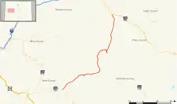
| Gesamtlänge: | 71,4 Meilen / 114,9 Kilometer |
| Anfangspunkt: | |
| Endpunkt: | |
| Countys: | Delta County Gunnison County Pitkin County Garfield County |
Der Highway beginnt am Colorado State Highway 82 in Carbondale und endet in Hotchkiss am Colorado State Highway 92. Der State Highway führt unter anderem über den McClure-Pass.
Weblinks
Commons: Colorado State Highway 133 – Sammlung von Bildern, Videos und Audiodateien
This article is issued from Wikipedia. The text is licensed under Creative Commons - Attribution - Sharealike. The authors of the article are listed here. Additional terms may apply for the media files, click on images to show image meta data.