Camporrotuno
| Gemeinde Aínsa-Sobrarbe: Camporrotuno | |||
|---|---|---|---|
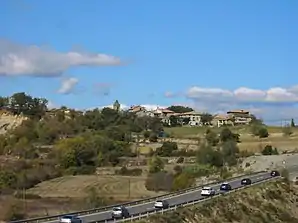 Camporrotuno und unten die Autobahn A-138 | |||
| Wappen | Karte von Spanien | ||
| ? Hilfe zu Wappen |
| ||
| Basisdaten | |||
| Autonome Gemeinschaft: | |||
| Provinz: | Huesca | ||
| Comarca: | Sobrarbe | ||
| Koordinaten | 42° 21′ N, 0° 10′ O | ||
| Höhe: | 578 msnm | ||
| Einwohner: | 21 (2019)INE | ||
| Ortskennzahl: | 22907000600 | ||


Camporrotuno ist ein spanischer Ort in der Provinz Huesca der Autonomen Gemeinschaft Aragonien. Camporrotuno gehört zur Gemeinde Aínsa-Sobrarbe. Der Ort auf 578 Meter Höhe liegt circa fünf Kilometer südlich von Aínsa. Camporrotuno hatte im Jahr 2019 nur 21 Einwohner.
Sehenswürdigkeiten
- Häuser aus dem 16. Jahrhundert
Weblinks

Arcusa | Arro | Bagüeste | Banastón | Buil | Bruello | Camporrotuno | Puivalleta | Castejón de Sobrarbe | Castellazo | Coroniellas | Coscojuela de Sobrarbe | El Coscollar | El Sarrastaño | El Sarrato | Frontinyán | Gabardilla | Gerbe | Griébal | Guaso | Jabierre de Olsón | La Capana | La Escapa | La Pardina | La Ripa | Las Bellostas | Latorre (Aínsa) | Latorrecilla | Linés | Mondot | Morillo de Tou | Olsón | Paúles de Sarsa | Pelegrín | Plampalacios | Sarratiás | Sarratillo | Sarsa de Surta | Tou | Urriales | Usana