Blaich (Schottland)
Blaich ist ein kleiner Ort am Südufer von Loch Eil. Als Ort von Croftern entstanden, zeigte die Ordnance Survey Karte von 1875 80 überdachte Häuser, auf der aktuellen Karte von 1975 sind es 33.[1][2] Eine Hütte von 1817, die zu einer Kirche umfunktioniert wurde, die gemeinsam von der Free Church of Scotland und der Church of Scotland genutzt wurde, ist seit etwa 20 Jahren dem Verfall preisgegeben.[3]
| Blaich schottisch-gälisch Blàthaich | |||
|---|---|---|---|
| Koordinaten | 56° 51′ N, 5° 12′ W | ||
| OS National Grid | NN049771 | ||
| |||
| Traditionelle Grafschaft | Argyll | ||
| Verwaltung | |||
| Postleitzahlenabschnitt | PH33 7 | ||
| Landesteil | Schottland | ||
| Council area | Highland | ||
| Britisches Parlament | Ross, Skye and Lochaber | ||
| Schottisches Parlament | Skye, Lochaber and Badenoch | ||
Bilder
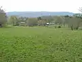 Häuser und landwirtschaftliche Flächen in Blaich
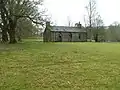 Die ehemalige Kirche 2007 (seit 2013 ohne Dach)
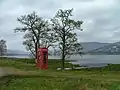 Blick auf das Loch vom Ort aus
Weblinks
Commons: Blaich – Sammlung von Bildern
Einzelnachweise
- Blaich. In: canmore.org.uk. Historic Environment Scotland, 2017, abgerufen am 11. September 2017 (englisch).
- Blaich. In: canmore.org.uk. Historic Environment Scotland, 2017, abgerufen am 11. September 2017 (englisch).
- Blaich Church of Scotland (Former), Blaich. In: buildingsatrisk.org.uk. 23. September 2013, abgerufen am 11. September 2017 (englisch).
This article is issued from Wikipedia. The text is licensed under Creative Commons - Attribution - Sharealike. The authors of the article are listed here. Additional terms may apply for the media files, click on images to show image meta data.