Barnard River
Der Barnard River ist ein Fluss im Osten des australischen Bundesstaates New South Wales.
| Barnard River | ||
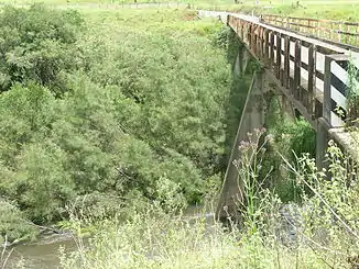
 Brücke des Thunderbolts Way über den Barnard River nördlich von Bretti Brücke des Thunderbolts Way über den Barnard River nördlich von Bretti | ||
| Daten | ||
| Lage | New South Wales, Australien | |
| Flusssystem | Manning River | |
| Abfluss über | Manning River → Tasmansee | |
| Quelle | bei Hanging Rock (Great Dividing Range nördlich des Ben-Halls-Gap-Nationalparks) 31° 30′ 23″ S, 151° 13′ 15″ O | |
| Quellhöhe | 1330 m[1] | |
| Mündung | Manning River bei Bretti 31° 47′ 19″ S, 151° 55′ 5″ O | |
| Mündungshöhe | 94 m[1] | |
| Höhenunterschied | 1236 m | |
| Sohlgefälle | 8,4 ‰ | |
| Länge | 148 km[1] | |
| Linke Nebenflüsse | Back River, Tomalla Creek, Myall Creek | |
| Rechte Nebenflüsse | Ben Halls Creek, Schofields Creek, Orham Creek, Curricabark River | |
Geographie
Er entspringt bei Hanging Rock in der Great Dividing Range nördlich des Ben-Halls-Gap-Nationalparks. Von dort fließt er nach Südosten und mündet bei Bretti östlich des Woko-Nationalparks in den Manning River.
Nebenflüsse mit Mündungshöhen
- Ben Halls Creek – 633 m
- Back River – 548 m
- Tomalla Creek – 503 m
- Schofields Creek – 366 m
- Orham Creek – 344 m
- Myall Creek – 195 m
- Curricabark River – 170 m[1]
Einzelnachweise
This article is issued from Wikipedia. The text is licensed under Creative Commons - Attribution - Sharealike. The authors of the article are listed here. Additional terms may apply for the media files, click on images to show image meta data.