Bargo River
Der Bargo River ist ein Fluss im Osten des australischen Bundesstaates New South Wales.
| Bargo River | ||
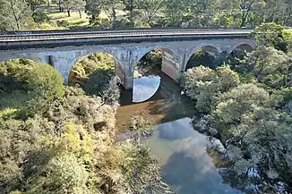 Eisenbahnbrücke über den Bargo River bei Tahmoor Eisenbahnbrücke über den Bargo River bei Tahmoor | ||
| Daten | ||
| Lage | New South Wales, Australien | |
| Flusssystem | Hawkesbury River | |
| Abfluss über | Nepean River → Hawkesbury River → Tasmansee | |
| Quelle | bei Hilltop (östlich des Nattai-Nationalparks) 34° 23′ 49″ S, 150° 29′ 37″ O | |
| Mündung | Nepean River bei Tahmoor 34° 14′ 0″ S, 150° 37′ 0″ O
| |
| Länge | ca. 32 km[1] | |
| Einzugsgebiet | 130,7 km²[2] | |
| Kleinstädte | Hilltop, Balmoral, Buxton, Bargo, Tahmoor | |
Er entspringt östlich der Bargo State Recreational Area im Südosten des Nattai-Nationalparks und fließt zunächst nach Norden und dann nach Nordosten, wo er bei Tahmoor in den Nepean River mündet.[1]
Die Kleinstadt Bargo liegt im Tal am östlichen Flussufer.[1]
Weblinks
Commons: Bargo River – Sammlung von Bildern, Videos und Audiodateien
Einzelnachweise
- Steve Parish: Australian Touring Atlas. Steve Parish Publishing, Archerfield QLD 2007, ISBN 978-1-74193-232-4. S. 24–25
- Bargo River Subcatchment. Hawkesbury-Nepean River Health Strategy (PDF; 326 kB)
This article is issued from Wikipedia. The text is licensed under Creative Commons - Attribution - Sharealike. The authors of the article are listed here. Additional terms may apply for the media files, click on images to show image meta data.