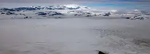
Bagley Icefield
Das Bagley Icefield (manchmal auch Bagley Ice Valley) in Alaska erstreckt sich im Kerngebiet der Saint Elias Mountains sowie Teilen der Chugach Mountains und ist das größte zusammenhängende Gletscher-Eisfeld außerhalb der Polregionen.[3]
| Bagley Icefield | ||
|---|---|---|
 | ||
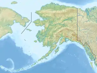
| Lage | Alaska (USA) | |
| Gebirge | Eliaskette, Chugach Mountains | |
| Typ | Plateaugletscher | |
| Länge | 200 km [1] | |
| Fläche | 5200 km² (einschließlich aller Tributär- und Auslassgletscher)[2] | |
| Breite | ⌀ 10 km [1] | |
| Eisdicke | max. 1000 m [1] | |
| Koordinaten | 60° 29′ N, 141° 35′ W | |
| ||
| Besonderheiten | Größtes Eisfeld außerhalb der Polregion | |
Es speist mehrere Dutzend Gletscher und bedeckt so insgesamt eine Fläche von etwa 5200 km².
Benannt wurde es nach James W. Bagley, einem USGS-Topografen, der die Bagley-T-3-Kamera entwickelte und Alaska vor Beginn des Ersten Weltkriegs kartografierte.
Das Eisfeld liegt im Schutzgebiet des Wrangell-St.-Elias-Nationalparks.
Weblinks
Commons: Bagley Icefield – Sammlung von Bildern, Videos und Audiodateien
Einzelnachweise
- National Park Service: Wrangell-St. Elias Park & Preserve – Glaciers
- Craig S. Lingle et al.: Dynamic Behavior of the Bering Glacier-Bagley Icefield System During a Surge, and Other Measurements of Alaskan Glaciers with ERS SAR Imagery. Third ERS Symposium on Space at the service of our Environment, Florenz 1997, bibcode:1997ESASP.414..995L
- National Geographic: Weird and Wild in the Parks Map
This article is issued from Wikipedia. The text is licensed under Creative Commons - Attribution - Sharealike. The authors of the article are listed here. Additional terms may apply for the media files, click on images to show image meta data.