Autopista Ma-1
Die Autopista Ma-1, kurz Ma-1, ist eine Regionalautobahn auf der spanischen Baleareninsel Mallorca.
| Autopista Ma-1 in Spanien | |
| Karte | |
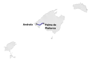 Verlauf der Ma 1 | |
| Basisdaten | |
| Betreiber: | |
| Straßenbeginn: | Palma de Mallorca |
| Straßenende: | Puerto de Andratx |
| Gesamtlänge: | 30,5 km davon 15 km Autopista |
|
Balearische Inseln | |
| Nutzungsvoraussetzung: | teilweise Mindestgeschwindigkeit |
| Ausbauzustand: | 2 × 2 Fahrstreifen |
Sie beginnt in der Hauptstadt Palma. Teilweise ist die Ma-1 dort auch sechsspurig ausgebaut. Die Straße darf in Palma aber als Ortsdurchfahrt nur mit max. 50 km/h befahren werden.
Zwischen den Ausfahrten 18 und 20 ist die Ma-1 als Autovia ausgeschildert, da es auf diesem Abschnitt keine alternative Straße für langsamere Fahrzeuge gibt.[1]
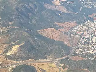
Die Autopista endet nach Abfahrt 20 und wird bis Puerto de Andratx als Landstraße weitergeführt. Die Ortsumfahrung von Peguera ist dabei noch kreuzungsfrei mit autobahnähnlichen Abfahrten ausgebaut.[2]
Straßenverlauf
| Anschlussstelle | km | Name der Anschlussstelle | Anschluss |
|---|---|---|---|
| Übergang aus Ma-19 | Palma
Avinguda Adolfo Suarez |
Ma-19 | |
| Palma
Avinguda d’Antoni Maura (nur mit Sondergenehmigung) |
|||
| Beginn Ma-1 | Palma
Avinguda de Gabriel Roca |
||
| 0,5 | Palma
Avinguda de l’Argentina |
||
| 1 | Palma
Carrer de Monsenyor Palmer |
||
| 2 | Palma | ||
| 2,2 | |||
| 2,4 | Palma
Carrer de la Pedrera |
||
| 3 | Palma
Carrer de Porto Pi Port de Palma embarcament vehicles |
||
| 4 | Palma
Avinguda de Joan Miró Carretera Dic de L’Oest |
||
Fahrtrichtung Puerto de Andratx |
4,2 | CALA MAJOR
SANT AGUSTÍ |
Ma-1C |
Fahrtrichtung Palma |
4,5 | CALA MAJOR
ILLETES | |
Fahrtrichtung Puerto de Andratx |
Ma-1 Autopista | ||
Fahrtrichtung Puerto de Andratx |
5 |
Gènova |
|
Fahrtrichtung Palma |
6 |
Cala Major | |
Fahrtrichtung Puerto de Andratx |
GÈNOVA
SANT AGUSTÍ |
Ma-1044 | |
Fahrtrichtung Palma |
6,5 | ||
| 9 | BENDINAT
ILLETES |
Castillo de Bendinat | |
| 10 | COSTA D'EN BLANES
PORTALS NOUS |
Av. Tomàs Blanes Tolosa | |
| 13 | CALVIÀ
PALMANOVA |
Ma-1015 | |
| 14 | MAGALUF
EL TORO Gewerbegebiet Son Bugadelles |
Ma-1C | |
| 17 | SANTA PONÇA
Gewerbegebiet Son Bugadelles CALVIÀ |
Ma-1014
Avinguda del Rei Jaume I | |
| 18 | COSTA DE LA CALMA | ||
Fahrtrichtung Puerto de Andratx |
Ma-1 Autopista | ||
Fahrtrichtung Palma |
|||
Fahrtrichtung Puerto de Andratx |
Ma-1 Autovia | ||
Fahrtrichtung Palma |
Ende Autovia | ||
| 19 | Túnel des Coll den Gorvió | ||
Fahrtrichtung Puerto de Andratx |
19,5 | PEGUERA
LA ROMANA |
Bulevar de Peguera |
Fahrtrichtung Palma |
Ma-1 Autovia | ||
Fahrtrichtung Puerto de Andratx |
20 | Ende Autovia | Ma-1 |
| 21 | Túnel de sa Coma | ||
Fahrtrichtung Puerto de Andratx |
22 | PEGUERA
ES CAPELLDÀ |
Ma-1012 |
Fahrtrichtung Puerto de Andratx |
23 | PEGUERA
CALA FORNELLS |
|
| 23,5 | Túnel de Son Vic | ||
| 25 | PEGUERA
CAMP DE MAR |
Ma-1A | |
| 26,5 | ANDRATX
ESTELLENCS SÓLLER |
Ma-1B | |
| 27,5 | Andratx | Ma-10 | |
| 29 | Ma-1022 | ||
| 31 | Puerto de Andratx | Ma-1020
Carrer des Saluet carretera des Port |
Einzelnachweise
- Mallorca-4you Finca & Ferienhausvermietung: Mallorca Insel-Karte | Land-Karte (Map) Mallorca mit Palma. Abgerufen am 30. Juli 2018 (deutsch).
- Mapas de carreteras :: Consell de Mallorca. Abgerufen am 30. Juli 2018 (spanisch).
- OpenStreetMap. Abgerufen am 30. Juli 2018.
Nationalstraßen (Autovía/Autopista)
A-1 – AP-1 |
A-2 – AP-2 |
A-3 |
A-4 – AP-4 |
A-5 |
A-6 – AP-6 |
A-7 – AP-7 |
AP-9 |
AP-9V |
A-11 |
A-12 |
A-13 |
A-14 |
A-15 – AP-15 |
AV-20 |
A-21 |
A-22 |
A-23 |
A-24 |
A-25 |
A-26 |
A-27 |
A-28 |
A-30 |
A-31 |
A-32 |
A-33 |
A-35 |
AP-36 |
AP-37 |
A-38 |
A-40 |
A-41 – AP-41 |
A-42 |
A-43 |
A-44 |
A-45 |
AP-46 |
A-48 |
A-49 |
A-50 |
AP-51 |
A-52 |
AP-53 |
A-54 |
A-55 |
A-56 |
A-57 |
A-58 |
A-59 |
A-60 |
AP-61 |
A-62 |
A-63 |
A-64 |
A-65 |
A-66 – AP-66 |
A-67 |
A-68 – AP-68 |
A-70 |
AP-71 |
A-72 |
A-73 |
A-74 |
A-75 |
A-76 |
A-77 |
A-78 |
A-79 |
A-81 |
A-83 |
A-91
Regionalautobahnen (Autopista)
Balearen (Ma-1 – Ma-13 – Ma-19 – Ma-20) |
Katalonien (C-16 – C-17 – C-25 – C-31 – C-32 – C-33 – C-35 – C-58 – C-60 – C-65 – C-66 – C-68) |
Gran Canaria (GC-1 – GC-2 – GC-3 – GC-4– GC-23) |
Teneriffa (TF-1 – TF-2 – TF-4 – TF-5) |
Fuerteventura (FV-1 – FV-2) |
Madrid (M-21 – M-23)