Auricherland
Das Auricherland ist eine historische Landschaft, gelegen im Zentrum Ostfrieslands, die ein weites Gebiet rund um die Stadt Aurich umfasst.[1]
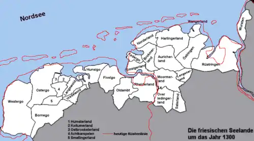
Die Friesischen Seelande um 1300

Ostfriesland um 1600, gezeichnet von Ubbo Emmius
Das Auricherland grenzt im Westen an das Bro(o)kmerland, im Norden an das Norder- und das Harlingerland, im Osten an Östringen und im Süden an das Lengener- und das Moormerland.[2]
Einzelnachweise
- Heinrich Schmidt, Christine van den Heuvel, Bernd Kappelhoff, Thomas Vogtherr: Land, Dorf und Kirche: Gemeindebildungen vom Mittelalter bis zur Neuzeit in Nordwestdeutschland. Peine 2009. ISBN 3775260536. S. 114.
- Siehe die nebenstehende Ostfrieslandkarte von Ubbo Emmius (ca. 1600)
This article is issued from Wikipedia. The text is licensed under Creative Commons - Attribution - Sharealike. The authors of the article are listed here. Additional terms may apply for the media files, click on images to show image meta data.