Arroyo Chuy del Tacuarí
Der Arroyo Chuy del Tacuarí (auch kurz Arroyo Chuy) ist ein auf dem Gebiet der Departamento Cerro Largo im Osten Uruguays gelegener kleiner Flusslauf.[1]
| Arroyo Chuy del Tacuarí | ||
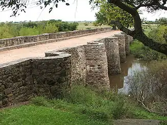 Brücke bei Posta del Chuy nahe Melo Brücke bei Posta del Chuy nahe Melo | ||
| Daten | ||
| Lage | Südamerika, Uruguay | |
| Flusssystem | Río Tacuarí | |
| Abfluss über | Río Tacuarí → Laguna Merín → Canal São Gonçalo → Lagoa dos Patos → Atlantik | |
| Quelle | in der Cuchilla Grande im Departamento Cerro Lago | |
| Mündung | Río Tacuarí 32° 32′ 42″ S, 54° 2′ 45″ W | |
| Mündungshöhe | 51 m
| |
| Länge | 45 km | |
Der Nebenfluss des Río Tacuarí entspringt in der Cuchilla Grande auf dem Gebiet von Cerro Largo und wird schon wenige Kilometer nach seiner Quelle zu einem kleinen See (ca. 1 km²) gestaut. Er bahnt sich danach seinen Weg von Norden nach Süden bis zur Mündung in den Río Tacuarí.[2] Etwa auf halbem Weg bildet er ein verzweigtes Sumpfgebiet in das mehrere Nebenflüsse fließen, bevor er etwa 22 km vor seiner Mündung sich wider sammelt.
→ Siehe auch: Liste der Flüsse in Uruguay
Einzelnachweise
This article is issued from Wikipedia. The text is licensed under Creative Commons - Attribution - Sharealike. The authors of the article are listed here. Additional terms may apply for the media files, click on images to show image meta data.