Arizona State Route 69
Die Arizona State Route 69 ist eine State Route im US-Bundesstaat Arizona, die in West-Ost-Richtung verläuft.

| |
|---|---|
| Karte | |
 | |
| Basisdaten | |
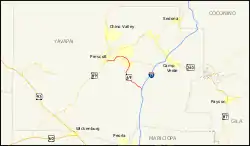
| Gesamtlänge: | 34 mi/54 km |
| Eröffnung: | 1968 |
| Anfangspunkt: | |
| Endpunkt: | |
| County: | Yavapai County |
Die State Route beginnt an der Arizona State Route 89 nahe Prescott und endet am Interstate 17. Nach etwa einem Fünftel der Strecke passiert die vierspurig ausgebaute Straße den Ort Prescott Valley. Vor dem Bau des I-17 begann die State Route in Phoenix am Black Canyon Highway.
Weblinks
Commons: Arizona State Route 69 – Sammlung von Bildern, Videos und Audiodateien
This article is issued from Wikipedia. The text is licensed under Creative Commons - Attribution - Sharealike. The authors of the article are listed here. Additional terms may apply for the media files, click on images to show image meta data.