Arizona State Route 66
Die Arizona State Route 66 (kurz AZ 66) ist eine State Route im US-Bundesstaat Arizona, die in Ost-West-Richtung verläuft.

| |
|---|---|
| Karte | |
 | |
| Basisdaten | |
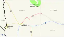
| Gesamtlänge: | 66,59 mi/107,17 km |
| Eröffnung: | 1984 |
| Anfangspunkt: | |
| Endpunkt: | |
| Countys: | Mohave County Coconino County Yavapai County |
Die State Route beginnt an der Interstate 40 in Kingman und endet nach 107 Kilometern in Seligman wieder an der I-40. Die State Route verläuft entlang eines Teils der ehemaligen Route 66. Die Route 66 führte weiter in Richtung Osten entlang der heutigen I-40 bis zur Grenze zu New Mexico.
Weblinks
Commons: Arizona State Route 66 – Sammlung von Bildern, Videos und Audiodateien
This article is issued from Wikipedia. The text is licensed under Creative Commons - Attribution - Sharealike. The authors of the article are listed here. Additional terms may apply for the media files, click on images to show image meta data.