Ardle (Fluss)
Der Ardle, veraltet auch Airdle, ist ein Fluss in der schottischen Council Area Perth and Kinross. Er entsteht durch den Zusammenfluss der Bäche Allt Fearnach und Brerachan Water etwa 14 km nordöstlich von Pitlochry[2][3]
| Ardle | ||
 | ||
| Daten | ||
| Lage | Perth and Kinross, Schottland | |
| Flusssystem | Tay | |
| Abfluss über | Ericht → Isla → Tay → Firth of Tay → Nordsee | |
| Quelle | Zusammenfluss der Bäche Allt Fearnach und Brerachan Water etwa 14 km nordöstlich von Pitlochry 56° 48′ 46″ N, 3° 35′ 41″ W | |
| Mündung | 0,5 Kilometer östlich von Bridge of Cally in den Ericht 56° 38′ 52″ N, 3° 23′ 26″ W | |
| Mündungshöhe | etwa 150 m ASL[1]
| |
| Länge | 21 km[2] | |
Der Ardle fließt in südöstlicher Richtung durch eine dünnbesiedelte, bergige Region. Ab etwa fünf Kilometer nach der Entstehung verläuft der Ardle bis zu seiner Mündung bei Bridge of Cally entlang der A924, welche die A93 bei Bridge of Cally mit der A9 bei Pitlochry verbindet. Der Ardle mündet nach insgesamt 21 km in den Ericht und gelangt somit über Isla und Tay schließlich in die Nordsee.[2][3]
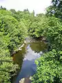 Der Ardle in Bridge of Cally kurz vor seiner Mündung
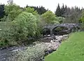 Brücke über den Ardle
Weblinks
Commons: Ardle – Sammlung von Bildern, Videos und Audiodateien
Einzelnachweise
- Ericht, River. In: Francis H. Groome: Ordnance Gazetteer of Scotland: A Survey of Scottish Topography, Statistical, Biographical and Historical. Band 3: (Edr – Eyn). Thomas C. Jack, Grange Publishing Works, Edinburgh u. a. 1883, S. 574–575.
- Airdle. In: Francis H. Groome: Ordnance Gazetteer of Scotland: A Survey of Scottish Topography, Statistical, Biographical and Historical. Band 1: (A – Coru). Thomas C. Jack, Grange Publishing Works, Edinburgh u. a. 1882, S. 36.
- Ardle, River. In: David Munro, Bruce Gittings: Scotland. An Encyclopedia of Places & Landscapes. Collins u. a., Glasgow 2006, ISBN 0-00-472466-6.
This article is issued from Wikipedia. The text is licensed under Creative Commons - Attribution - Sharealike. The authors of the article are listed here. Additional terms may apply for the media files, click on images to show image meta data.