Ailortelu
Ailortelu ist eine osttimoresische Siedlung im Suco Acumau (Verwaltungsamt Remexio, Gemeinde Aileu).[1]
| Ailortelu | |||
|---|---|---|---|
| |||
| Koordinaten | 8° 37′ S, 125° 40′ O | ||
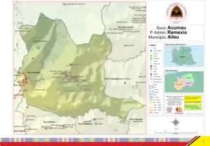 Karte des Sucos Acumau Karte des Sucos Acumau | |||
| Basisdaten | |||
| Staat | Osttimor | ||
| Aileu | |||
| Verwaltungsamt | Remexio | ||
| Suco | Acumau | ||
| Aldeia | Aimerahun | ||
| Höhe | 876 m | ||
Geographie
Die Siedlung (Bairo) Ailortelu liegt im Zentrum der Aldeia Aimerahun, auf einer Meereshöhe von 876 m. Sie befindet sich südöstlich vom Zentrum von Remexio, dem Hauptort des Verwaltungsamtes und des Sucos, an der Straße zum Suco Fadabloco im Süden. Direkter Nachbarort im Norden ist das Dorf Aicoarema.[1] Nordöstlich passiert der Fluss Aikoereima die beiden Orte, ein Quellfluss des Nördlichen Laclós.[2]
Einzelnachweise
- Direcção-Geral de Estatística: Atlas der Gemeinde Aileu, abgerufen am 21. März 2021.
- Timor-Leste GIS-Portal (Memento vom 30. Juni 2007 im Internet Archive)
This article is issued from Wikipedia. The text is licensed under Creative Commons - Attribution - Sharealike. The authors of the article are listed here. Additional terms may apply for the media files, click on images to show image meta data.