Wat’s Dyke
Wat’s Dyke ist ein über 60 km langer Wall in der walisisch-englischen Grenzregion Welsh Marches. Der Wall verläuft hier unter anderem an Oswestry vorbei.
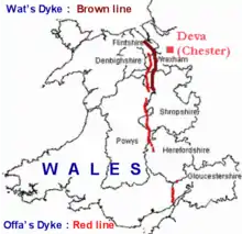
Lage von Wat’s Dyke (braune Linie) und Offa’s Dyke (rote Linie)
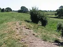
Wat’s Dyke nahe Northop
Die Historiker einigten sich auf das achte Jahrhundert als Entstehungszeitraum, doch verweisen C14-Messungen nun auf das fünfte Jahrhundert.
Literatur
- Margaret Worthington: Wat’s Dyke: An Archaeological and Historical Enigma. Bulletin John Rylands Library, Manchester, Vol 79, no. 3, 1997.
- H. R. Hannaford: Archaeological on Wat’s Dyke at Maes-y-Clawdd. Archaeology Service, Shropshire County Council, report no. 132., Dezember 1997.
This article is issued from Wikipedia. The text is licensed under Creative Commons - Attribution - Sharealike. The authors of the article are listed here. Additional terms may apply for the media files, click on images to show image meta data.