Terres de l’Ebre
Das Terres de l’Ebre ist eines von sieben Territorien (àmbits funcionals territorials), in der Autonomen Gemeinschaft Katalonien, das 1995 mit dem Regionalplan (Pla territorial general de Catalunya) durch Gesetz beschlossen wurde.
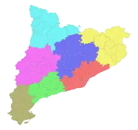
Aufteilung Kataloniens in 7 Regionen nach dem Regionalplan von 1995:Àmbit metropolità Alt Pirineu i Aran Camp de Tarragona Comarques Centrals Comarques Gironines Ponent Terres de l’Ebre
Terres de l’Ebre hat eine Fläche von 3.339 km² und hat 159.383 Einwohner (2009). Das Territorium liegt im äußersten Südwesten Kataloniens an der Grenze zu den Autonomen Gemeinschaften Aragonien und Valencia. Alle 4 Comarcas des Ámbits liegen am Unterlauf des Río Ebro.
Stand: 2009
| Gemeinde | Einwohner | Fläche (km²) |
|---|---|---|
| Baix Ebre | 67.050 | 1.035 |
| Montsià | 58.151 | 728 |
| Ribera d’Ebre | 21.951 | 835 |
| Terra Alta | 12.231 | 741 |
Àmbits funcionals territorials (AFT)
Siehe auch
This article is issued from Wikipedia. The text is licensed under Creative Commons - Attribution - Sharealike. The authors of the article are listed here. Additional terms may apply for the media files, click on images to show image meta data.