Te Manga
Te Manga ist mit einer Höhe von 652 Metern der höchste Berg der Cookinseln im südlichen Pazifik. Er liegt im Nordosten der Hauptinsel Rarotonga und ist komplett bewaldet.
| Te Manga | ||
|---|---|---|
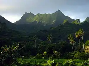
Te Manga, Ansicht von der Südküste Rarotongas | ||
| Höhe | 652 m | |
| Lage | Nordwesten der Insel Rarotonga | |
| Koordinaten | 21° 14′ 8″ S, 159° 45′ 50″ W | |
| ||
| Besonderheiten | höchster Berg der Cookinseln | |
Siehe auch
Weblinks
- Te Manga auf Peakbagger.com (englisch)
- Te Manga, Rarotonga – Tramping New Zealand
This article is issued from Wikipedia. The text is licensed under Creative Commons - Attribution - Sharealike. The authors of the article are listed here. Additional terms may apply for the media files, click on images to show image meta data.