St. Mary’s Island (Themse)
St Mary’s Island ist eine Insel in der Themse. Die Insel liegt in einem Abschnitt des Flusses, der im Westen von Reading von dessen Vororten Caversham im Norden und Tilehurst im Süden eingegrenzt wird. Die Insel liegt an der Nordseite des Flusses, nördlich vom Buck’s Eyot.
| St Mary’s Island | ||
|---|---|---|
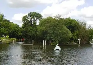 St Mary’s Island – Blickrichtung flussaufwärts | ||
| Gewässer | Themse | |
| Geographische Lage | 51° 28′ N, 1° 0′ W | |
| ||
| Einwohner | unbewohnt | |
Quellen
- Reading, Windsor, Henley-on-Thames & Bracknell (= Landranger Map. Band 175). Ordnance Survey, Southampton 2012, ISBN 978-0-319-23214-9.
Siehe auch
This article is issued from Wikipedia. The text is licensed under Creative Commons - Attribution - Sharealike. The authors of the article are listed here. Additional terms may apply for the media files, click on images to show image meta data.