Sputnik-Inseln
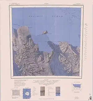
Die Sputnik-Inseln (russisch Острова Спутники Ostrowa Sputniki) sind zwei vereiste und deutlich unterschiedlich große Inseln vor der Pennell-Küste des ostantarktischen Viktorialands. Sie liegen zwischen Kap Cheetham und Kap Williams in der Einfahrt zur Ob’ Bay. Die größere nordöstliche Insel misst 30,3 km², die kleinere südwestliche 1,3 km². Die größere Insel erreicht eine Höhe von 330 m.
| Sputnik-Inseln | ||
|---|---|---|
 Topographische Karte der Ob’ Bay mit den Sputnik-Inseln | ||
| Gewässer | Ob’ Bay | |
| Geographische Lage | 70° 22′ S, 163° 22′ O | |
| ||
| Anzahl der Inseln | 2 | |
| Hauptinsel | (nordöstliche) | |
| Gesamte Landfläche | 31,6 km² | |
| Einwohner | unbewohnt | |
Erste Luftaufnahmen entstanden bei der US-amerikanischen Operation Highjump (1946–1947). Wissenschaftler einer sowjetischen Antarktisexpedition nahmen 1958 Vermessungen und die Benennung vor. Namensgebend ist der erste künstliche Erdsatellit Sputnik 1.
Weblinks
- Sputnik Islands im Geographic Names Information System des United States Geological Survey (englisch)
- Sputnik Islands auf geographic.org (englisch)
This article is issued from Wikipedia. The text is licensed under Creative Commons - Attribution - Sharealike. The authors of the article are listed here. Additional terms may apply for the media files, click on images to show image meta data.
