Skillet Fork
Der Skillet Fork ist ein rechter Nebenfluss des Little Wabash River im US-Bundesstaat Illinois. Der Fluss ist 158 km lang und entwässert im Südosten von Illinois ein Areal von 2742 km².
| Skillet Fork | ||
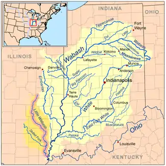 Flusslauf im Einzugsgebiet des Wabash River Flusslauf im Einzugsgebiet des Wabash River | ||
| Daten | ||
| Gewässerkennzahl | US: 418570 | |
| Lage | Illinois (USA) | |
| Flusssystem | Mississippi River | |
| Abfluss über | Little Wabash → Wabash → Ohio → Mississippi → Golf von Mexiko | |
| Quelle | im Marion County 38° 48′ 11″ N, 88° 43′ 6″ W | |
| Mündung | nördlich von Carmi in den Little Wabash River 38° 7′ 53″ N, 88° 7′ 32″ W | |
| Mündungshöhe | 110 m[1]
| |
| Länge | 158 km[1] | |
| Einzugsgebiet | 2742 km²[2] | |
| Abfluss am Pegel Wayne City[3] AEo: 1201 km² |
MQ 1929/1016 Mq 1929/1016 |
12,2 m³/s 10,2 l/(s km²) |
| Rechte Nebenflüsse | Horse Creek, Main Outlet | |
| Gemeinden | Wayne City | |
Der Skillet Fork entspringt im Nordosten des Marion County, etwa 25 km nordöstlich von Salem. Er fließt anfangs in südlicher Richtung. Bei der Ortschaft Wayne City, der einzigen größeren Siedlung am Flusslauf, wendet er sich nach Ostsüdost. Er mündet schließlich 8 km nördlich der Kleinstadt Carmi in den Little Wabash River.
Der Fluss weist ein stark mäandrierendes Verhalten auf. Unterhalb von Wayne City wurde er jedoch an zahlreichen Stellen begradigt und kanalisiert. Nennenswerte Nebenflüsse des Skillet Fork sind Horse Creek und Main Outlet (beide von rechts).[2]
Einzelnachweise
- Skillet Fork im Geographic Names Information System des United States Geological Survey
- H.Vernon Knapp, Michael W. Myers: Streamflow Assessment Model for the Little Wabash River Watershed: Hydrologic Analysis (PDF 1,4 MB) Illinois Dept. of Natural Resources. Abgerufen am 30. Juli 2017.
- USGS 03380500 SKILLET FORK AT WAYNE CITY, IL