Sinuosität
Die Sinuosität (von lateinisch sinus ‚Bucht‘, ‚Meerbusen‘) ist ein einfaches Maß für die Intensität des Mäandrierens eines Flusses bzw. Fließgewässers. Neben der Geomorphologie wird der Begriff auch in der Routenplanung für das Kurven und Distanzenverhältnis von Straßen verwendet.[1]

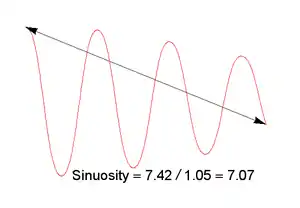
Berechnung der Sinuosität für eine oszillierende Kurve
Sie wird als Quotient aus der Länge eines Fluss- oder anderen Streckenabschnittes und der geradlinigen Distanz zwischen Anfangs- und Endpunkt berechnet.[2]
- mit
- P: Sinuosität
- L: Länge des Flussabschnittes (SI-Einheit: m)
- D: geradlinige Distanz zwischen Anfangs- und Endpunkt von L (SI-Einheit: m)
Einzelnachweise
- Geographical Access to Services, Health (GASH): Modelling Population Access to New Zealand Public Hospitals (PDF; 676 kB) Road layers often contain information that describes the road characteristics and additional information on the bendiness of the roads can be obtained from calculating the sinuosity of the roads.
- F. Ahnert: Einführung in die Geomorphologie. 4. Auflage. 2009, 393 S.
This article is issued from Wikipedia. The text is licensed under Creative Commons - Attribution - Sharealike. The authors of the article are listed here. Additional terms may apply for the media files, click on images to show image meta data.