Rotuma-Inseln
Die Rotuma-Inseln sind eine kleine südpazifische Inselgruppe, die das abhängige Gebiet Rotuma des Staates Fidschi bilden. Sie bestehen aus etwa neun bewaldeten Inseln vulkanischen Ursprungs.
| Rotuma-Inseln | ||
|---|---|---|
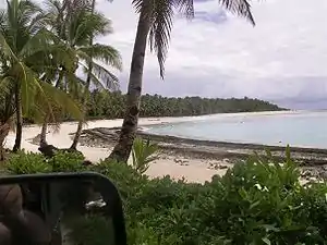 Mofmanu Beach bei Motusa auf der Hauptinsel | ||
| Gewässer | Pazifischer Ozean | |
| Geographische Lage | 12° 30′ S, 177° 5′ O | |
| ||
| Anzahl der Inseln | 14 | |
| Hauptinsel | Rotuma Island | |
| Gesamte Landfläche | 46 km² | |
| Einwohner | 2095 (2007) | |
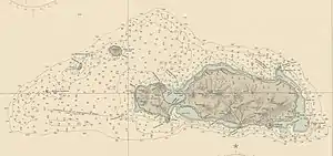 Seekarte der Rotuma-Inseln | ||
Geographie
Die Inselgruppe liegt rund 570 km nördlich der Fidschi-Hauptinsel Viti Levu und 469 km nordwestlich der nächstgelegenen Fidschi-Insel Thikombia. Nächstgelegene Landmasse ist Niulakita, die 369 Kilometer nordöstlich der Gruppe liegt. Die Gruppe besteht u. a. folgende Inseln:
![]() Karte mit allen Koordinaten: OSM | WikiMap
Karte mit allen Koordinaten: OSM | WikiMap
| Insel | Fläche (ha) |
Distanz zur Hauptinsel (m) |
Lage/Bemerkungen | Koordinaten |
|---|---|---|---|---|
| Rotuma Island | 4410 | - | Hauptinsel | 12° 30′ 00,0″ S, 177° 05′ 00,0″ O |
| Hof Vea | 0,06 | 590 | vor Oinafa (Nordosten) | 12° 28′ 50,0″ S, 177° 07′ 26,0″ O |
| Haua Mea‘me‘a | 1,5 | 620 | vor Oinafa (Nordosten) | 12° 28′ 50,0″ S, 177° 07′ 24,0″ O |
| Haua Ti‘u | 3,1 | 820 | vor Oinafa (Nordosten) | 12° 28′ 42,0″ S, 177° 07′ 30,0″ O |
| Husia Mea‘me‘a | 0,02 | 200 | vor Noa‘tau (Osten) | 12° 30′ 59,0″ S, 177° 08′ 23,0″ O |
| Husia Ti‘u | 0,3 | 170 | vor Noa‘tau (Osten) | 12° 31′ 02,0″ S, 177° 08′ 23,0″ O |
| ‘Afgaha | 3,8 | 1170 | vor Noa‘tau (Osten), und Husia Rua | 12° 31′ 21,0″ S, 177° 08′ 52,0″ O |
| Sari‘i Island | 0,36 | 420 | vor Noa‘tau (Osten) | 12° 31′ 36,3″ S, 177° 07′ 11,8″ O |
| Solkope | 31,5 | 40 | vor Noa‘tau (Osten) | 12° 31′ 27,0″ S, 177° 07′ 02,0″ O |
| Solnohu | 9,6 | 70 | vor Juju (Süden) | 12° 31′ 34,0″ S, 177° 05′ 28,0″ O |
| Uea | 73 | 3220 | Westen, zu Ituʻmuta[1] | 12° 27′ 59,0″ S, 176° 59′ 28,0″ O |
| Hafhaveiaglolo | 0,08 | 3220 | Westen | 12° 28′ 08,2″ S, 176° 58′ 16,3″ O |
| Hofhahoi | 0,41 | 5200 | Westen, nahe Hạfhai | 12° 28′ 34,4″ S, 176° 57′ 47,9″ O |
| Hatana | 3,7 | 5200 | Westen, zu Losa in Ituʻtiʻu | 12° 28′ 43,1″ S, 176° 57′ 41,4″ O |
| Hạf’liua | 6,1 | 7400 | Westen, zu Ituʻtiʻu | 12° 29′ 53,0″ S, 176° 56′ 06,0″ O |
| Rotuma (Inselgruppe) | 4600 | - | Inselgruppe | 12° 30′ 00,0″ S, 177° 05′ 00,0″ O |
Lediglich die Hauptinsel (Rotuma) ist bewohnt. Uea war bis in die 1930er Jahre bewohnt, mit dem gleichnamigen Dorf im Osten. Die Inseln der Gruppe liegen entweder auf dem Saumriff von Rotuma Island oder innerhalb (z. B. Solkope), oder in den Western Islands,[2] einer acht Kilometer langen Inselkette von Uea im Norden bis Hạf’liua im Süden, die 3,2 bis 7,4 Kilometer westlich der Hauptinsel liegt.
Einzelnachweise
- John Stanley Gardiner: The Natives of Rotuma. IX. Districts and their Government. In: The Journal of the Anthropological Institute of Great Britain and Ireland, 1898, Vol. 27, S. 396–435, hier S. 428 (online)
- John Stanley Gardiner: The Geology of Rotuma. In: The Quarterly Journal of the Geological Society of London, Vol. 54, Feb. 1898, S. 1–10 (online, DOI)