Roman Four Promontory
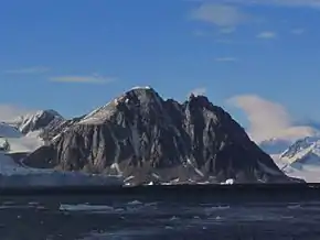
Die Roman Four Promontory (englisch für Römisch-Vier-Landspitze, in Argentinien Promontorio Cuarto Romano, in Chile Punta Cuatro Romano) ist eine bis zu 830 m hohe Landspitze an der Fallières-Küste des Grahamlands auf der Antarktischen Halbinsel. Sie markiert die nördliche Begrenzung der Einfahrt zum Neny-Fjord.
| Roman Four Promontory | ||
 | ||
| Geographische Lage | ||
| ||
| Koordinaten | 68° 13′ S, 66° 56′ W | |
| Lage | Grahamland, Antarktische Halbinsel | |
| Küste | Fallières-Küste | |
| Gewässer | Marguerite Bay | |
| Gewässer 2 | Neny-Fjord | |
| Höhe | 830 m | |

Eine erste Kartierung nahmen Teilnehmer der British Graham Land Expedition (1934–1937) unter der Leitung des australischen Polarforschers John Rymill vor. Benannt wurde sie durch Teilnehmer der United States Antarctic Service Expedition (1939–1941). Namensgebend war die Anordnung schneegefüllter Felsspalten am Rand der Landspitze in Form einer römischen Vier (IV).
Weblinks
- Roman Four Promontory im Geographic Names Information System des United States Geological Survey (englisch)
- Roman Four Promontory auf geographic.org (englisch)
This article is issued from Wikipedia. The text is licensed under Creative Commons - Attribution - Sharealike. The authors of the article are listed here. Additional terms may apply for the media files, click on images to show image meta data.