Rima Reiko
Rima Reiko ist eine sehr kleine Mondrille auf dem Erdmond, in der Ebene des Mare Serenitatis, nordöstlich des Kraters Dawes.
| Rima Reiko | ||
|---|---|---|
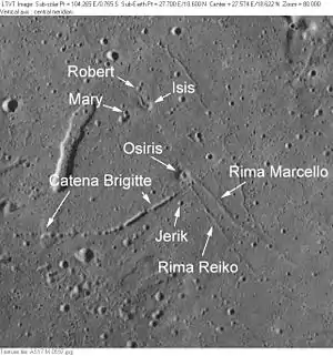 | ||
| Rima Reiko und Umgebung (Aufnahme Apollo 17) | ||
| ||
| Position | 18,55° N, 27,7° O | |
| Durchmesser | 4 km | |
| Benannt nach | japanischer Frauenname | |
| Siehe auch Gazetteer of Planetary Nomenclature | ||
Die namentliche Bezeichnung geht auf eine ursprünglich inoffizielle Bezeichnung auf Blatt 42C3/S2[1] der Topophotomap-Kartenserie der NASA zurück, die von der IAU 1976 übernommen wurde.[2]
Weblinks
- Rima Reiko im Gazetteer of Planetary Nomenclature der IAU (WGPSN) / USGS
- Rima Reiko auf The-Moon Wiki
Einzelnachweise
- Topophotomap 42C3/S2
- Exzerpt der Proceedings der 16. Generalversammlung der IAU (Grenoble 1976). In: Transactions of the IAU Bd. XVIB, Hrsg. von D. Riedel, 1977
This article is issued from Wikipedia. The text is licensed under Creative Commons - Attribution - Sharealike. The authors of the article are listed here. Additional terms may apply for the media files, click on images to show image meta data.