Punta Nizuc
Punta Nizuc im mexikanischen Bundesstaat Quintana Roo ist ein sandiger Landvorsprung am südlichsten Ende der Isla Cancún.
Costa Occidental de Isla Mujeres, Punta Cancún y Punta Nizuc
| ||
| Lage | ||
| Fläche | 8.673,06 ha (davon 0,61 ha Landfläche)[1] | |
| Geographische Lage | 21° 1′ N, 86° 46′ W | |
| ||
| Einrichtungsdatum | 19. Juli 1996[2] | |
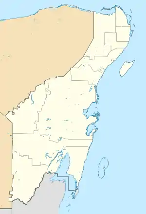
Punta Nizuc, gekennzeichnet als Poligono 3 im Nationalpark.
Lage
Das Gebiet gehört zum Hauptriff, das parallel zur Küstenlinie an der Halbinsel Yucatán verläuft. Es beherbergt zahlreiche Korallenformationen und ist seit 1996 Teil des Nationalparks Costa Occidental de Isla Mujeres, Punta Cancún y Punta Nizuc.
Puntas
Auf der Halbinsel Yucatán wird der Begriff Punta genutzt, um Formationen, die in Verbindung zur Küstenlinie stehen, zu bezeichnen.
Kunst
- La Jardinera del la Esperanza (The Garden of Hope), in 4 m Wassertiefe vor Punta Nizuc, Unterwasserskulptur von Jason deCaires Taylor
Literatur
- Yucatán en el tiempo. Enciclopedia Alfabética. México 1998. ISBN 970-9071-04-1
Einzelnachweise
- Ficha S I M E C | Comisión Nacional de Áreas Naturales Protegidas | Gobierno | gob.mx. Abgerufen am 1. Oktober 2018.
- Ficha S I M E C | Comisión Nacional de Áreas Naturales Protegidas | Gobierno | gob.mx. Abgerufen am 1. Oktober 2018.
This article is issued from Wikipedia. The text is licensed under Creative Commons - Attribution - Sharealike. The authors of the article are listed here. Additional terms may apply for the media files, click on images to show image meta data.